Nashua geodata
Nashua (New Hampshire) is a populated place; located in United States in America/New_York (GMT-4) time zone. With population of 87,970 people, there are 425 cities with bigger population in this country. Compared to other cities in United States, 81.7% of cities are located further ↓South; 96.7% of cities are located further ←West and 78.8% of cities have higher elevation than Nashua. Note1
Administrative division(s):
- Level 1: New Hampshire
- Level 2: Hillsborough County
- Level 3: City of Nashua


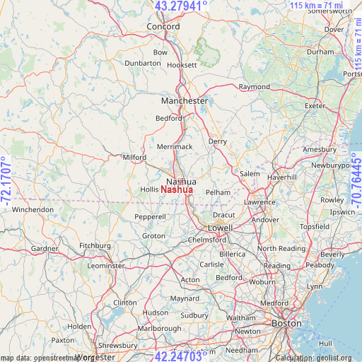
Nashua GPS coordinates[2]
42° 45' 55.332" North, 71° 28' 3.252" West
| Map corner | latitude | longitude |
|---|---|---|
| Upper-left | 43.27941°, | -72.1707° |
| Center: | 42.76537°, | -71.46757° |
| Lower-right: | 42.24703°, | -70.76445° |
| Map W x H: | 114.8×114.8 km | = 71.3×71.3mi |
| max Lat: | 71.29058° ⇑18.3% North |
| Nashua: | 42.76537° |
| min Lat: | ⇓81.7% South 19.06759° |
| min Long | Nashua | max Long |
| -171.73463° | -71.46757° | -66.98998° |
| W 96.7%⇐ | ⇒3.3% E |
Elevation
Elevation of Nashua is 52 m = 171 ft, and this is 242.8 m = 797 ft below average elevation for this country.
| Max E: |
3189 m = 10463 ft | 78.8% |
| Avg. | 294.8 m = 967 ft | |
| Nashua | 52 m = 171 ft | |
Min E: |
-60 m = -197 ft | 21.2% |
See also: Nashua elevation on elevation.city.
Geographical zone
Nashua is located in North temperate zone (between Tropic of Cancer and the Arctic Circle). Distance of this Northern Tropic circle is 2149.1 km =1335.4 mi to South.| Distance of | km | miles | from Nashua |
|---|---|---|---|
| North Pole | 5252 | 3263.4 | to North |
| Arctic Circle | 2646.1 | 1644.2 | to North |
| Tropic Cancer | 2149.1 | 1335.4 | to South |
| Equator | 4755.1 | 2954.7 | to South |


Nearby cities:
15 places around Nashua: (largest is in red/bold)
• Amherst
16.7 km =10.4 mi,  309°
309°
• Brookline
15.9 km =9.9 mi,  257°
257°
• Dunstable
10.1 km =6.3 mi,  187°
187°
• East Merrimack
11.5 km =7.1 mi,  353°
353°
• East Pepperell
14.1 km =8.8 mi,  217°
217°
• Hollis
10.4 km =6.5 mi, 256°
• Hudson
2.3 km =1.4 mi,  91°
91°
• Litchfield
8.8 km =5.5 mi, 353°
• Londonderry
13.5 km =8.4 mi,  34°
34°
• Merrimack
11.3 km =7 mi, 349°
• Milford
16.7 km =10.4 mi,  297°
297°
• Pelham
12.2 km =7.6 mi,  106°
106°
• Pepperell
14.8 km =9.2 mi, 221°
• Tyngsboro
10.5 km =6.5 mi,  160°
160°
• Windham
13.9 km =8.6 mi,  73°
73°
Sources, notices
• [Note1] Compared only with cities in United States existing in our database
• [Src1] Map data: © OpenStreetMap contributors (CC-BY-SA)
• [Src2] Other city data from geonames.org with taken over terms of usage.
• [Src3] Geographical zone / Annual Mean Temperature by Robert A. Rohde @ Wikipedia
