Litchfield geodata
Litchfield (New Hampshire) is a populated place; located in United States in America/New_York (GMT-4) time zone. With population of 8,307 people, there are 5129 cities with bigger population in this country. Compared to other cities in United States, 82.2% of cities are located further ↓South; 96.7% of cities are located further ←West and 80.3% of cities have higher elevation than Litchfield. Note1
Administrative division(s):
- Level 1: New Hampshire
- Level 2: Hillsborough County
- Level 3: Town of Litchfield


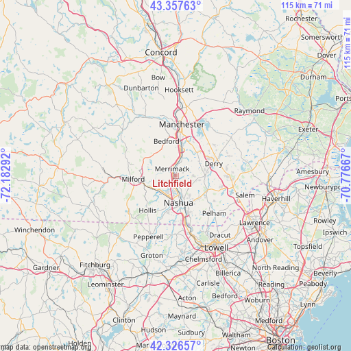
Litchfield GPS coordinates[2]
42° 50' 39.3" North, 71° 28' 47.244" West
| Map corner | latitude | longitude |
|---|---|---|
| Upper-left | 43.35763°, | -72.18292° |
| Center: | 42.84425°, | -71.47979° |
| Lower-right: | 42.32657°, | -70.77667° |
| Map W x H: | 114.6×114.6 km | = 71.2×71.2mi |
| max Lat: | 71.29058° ⇑17.8% North |
| Litchfield: | 42.84425° |
| min Lat: | ⇓82.2% South 19.06759° |
| min Long | Litchfield | max Long |
| -171.73463° | -71.47979° | -66.98998° |
| W 96.7%⇐ | ⇒3.3% E |
Elevation
Elevation of Litchfield is 45 m = 148 ft, and this is 249.8 m = 820 ft below average elevation for this country.
| Max E: |
3189 m = 10463 ft | 80.3% |
| Avg. | 294.8 m = 967 ft | |
| Litchfield | 45 m = 148 ft | |
Min E: |
-60 m = -197 ft | 19.7% |
See also: United States elevation on elevation.city.
Geographical zone
Litchfield is located in North temperate zone (between Tropic of Cancer and the Arctic Circle). Distance of this Northern Tropic circle is 2157.9 km =1340.9 mi to South.| Distance of | km | miles | from Litchfield |
|---|---|---|---|
| North Pole | 5243.2 | 3258 | to North |
| Arctic Circle | 2637.3 | 1638.7 | to North |
| Tropic Cancer | 2157.9 | 1340.9 | to South |
| Equator | 4763.8 | 2960.1 | to South |


Nearby cities:
15 places around Litchfield: (largest is in red/bold)
• Amherst
12 km =7.5 mi,  279°
279°
• Bedford
11.7 km =7.3 mi,  345°
345°
• Derry
13.1 km =8.1 mi,  71°
71°
• Derry Village
14.7 km =9.1 mi, 68°
• East Merrimack
2.7 km =1.7 mi, 353°
• Hollis
14.5 km =9 mi,  219°
219°
• Hudson
9.4 km =5.8 mi,  159°
159°
• Londonderry
8.9 km =5.5 mi, 74°
• Manchester
17 km =10.6 mi,  6°
6°
• Merrimack
2.6 km =1.6 mi,  334°
334°
• Milford
13.8 km =8.6 mi,  265°
265°
• Mont Vernon
16.8 km =10.4 mi,  289°
289°
• Nashua
8.8 km =5.5 mi,  173°
173°
• Pinardville
16.8 km =10.4 mi, 352°
• Windham
15.1 km =9.4 mi,  108°
108°
Sources, notices
• [Note1] Compared only with cities in United States existing in our database
• [Src1] Map data: © OpenStreetMap contributors (CC-BY-SA)
• [Src2] Other city data from geonames.org with taken over terms of usage.
• [Src3] Geographical zone / Annual Mean Temperature by Robert A. Rohde @ Wikipedia
