Cedar Grove geodata
Cedar Grove (New Jersey) is a populated place; located in United States in America/New_York (GMT-4) time zone. With population of 12,457 people, there are 3782 cities with bigger population in this country. Compared to other cities in United States, 64% of cities are located further ↓South; 89.4% of cities are located further ←West and 70.9% of cities have higher elevation than Cedar Grove. Note1
Administrative division(s):
- Level 1: New Jersey
- Level 2: Essex County
- Level 3: Township of Cedar Grove


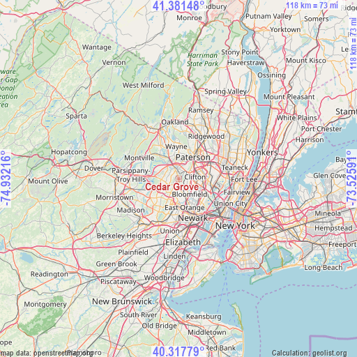
Cedar Grove GPS coordinates[2]
40° 51' 6.372" North, 74° 13' 44.508" West
| Map corner | latitude | longitude |
|---|---|---|
| Upper-left | 41.38148°, | -74.93216° |
| Center: | 40.85177°, | -74.22903° |
| Lower-right: | 40.31779°, | -73.52591° |
| Map W x H: | 118.3×118.3 km | = 73.5×73.5mi |
| max Lat: | 71.29058° ⇑36% North |
| Cedar Grove: | 40.85177° |
| min Lat: | ⇓64% South 19.06759° |
| min Long | Cedar Grove | max Long |
| -171.73463° | -74.22903° | -66.98998° |
| W 89.4%⇐ | ⇒10.6% E |
Elevation
Elevation of Cedar Grove is 95 m = 312 ft, and this is 199.8 m = 656 ft below average elevation for this country.
| Max E: |
3189 m = 10463 ft | 70.9% |
| Avg. | 294.8 m = 967 ft | |
| Cedar Grove | 95 m = 312 ft | |
Min E: |
-60 m = -197 ft | 29.1% |
See also: United States elevation on elevation.city.
Geographical zone
Cedar Grove is located in North temperate zone (between Tropic of Cancer and the Arctic Circle). Distance of this Northern Tropic circle is 1936.4 km =1203.2 mi to South.| Distance of | km | miles | from Cedar Grove |
|---|---|---|---|
| North Pole | 5464.8 | 3395.7 | to North |
| Arctic Circle | 2858.9 | 1776.4 | to North |
| Tropic Cancer | 1936.4 | 1203.2 | to South |
| Equator | 4542.3 | 2822.5 | to South |


Nearby cities:
15 places around Cedar Grove: (largest is in red/bold)
• Brookdale
4.4 km =2.7 mi,  117°
117°
• Caldwell
4.2 km =2.6 mi,  251°
251°
• Clifton
5.5 km =3.4 mi,  82°
82°
• Essex Fells
5.6 km =3.5 mi,  237°
237°
• Glen Ridge
5.6 km =3.5 mi,  157°
157°
• Little Falls
2.6 km =1.6 mi,  42°
42°
• Montclair
3.3 km =2.1 mi,  149°
149°
• North Caldwell
2.9 km =1.8 mi,  300°
300°
• Singac
4 km =2.5 mi,  345°
345°
• Upper Montclair
2.4 km =1.5 mi,  104°
104°
• Verona
2.6 km =1.6 mi,  200°
200°
• West Caldwell
5.7 km =3.5 mi,  266°
266°
• West Orange
6 km =3.7 mi,  188°
188°
• Westville
6 km =3.7 mi,  262°
262°
• Woodland Park
5.1 km =3.2 mi,  34°
34°
Sources, notices
• [Note1] Compared only with cities in United States existing in our database
• [Src1] Map data: © OpenStreetMap contributors (CC-BY-SA)
• [Src2] Other city data from geonames.org with taken over terms of usage.
• [Src3] Geographical zone / Annual Mean Temperature by Robert A. Rohde @ Wikipedia
