Clifton geodata
Clifton (New Jersey) is a populated place; located in United States in America/New_York (GMT-4) time zone. With population of 86,334 people, there are 446 cities with bigger population in this country. Compared to other cities in United States, 64.1% of cities are located further ↓South; 89.7% of cities are located further ←West and 77.9% of cities have higher elevation than Clifton. Note1


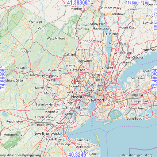
Clifton GPS coordinates[2]
40° 51' 30.348" North, 74° 9' 49.536" West
| Map corner | latitude | longitude |
|---|---|---|
| Upper-left | 41.38809°, | -74.86689° |
| Center: | 40.85843°, | -74.16376° |
| Lower-right: | 40.3245°, | -73.46064° |
| Map W x H: | 118.3×118.3 km | = 73.5×73.5mi |
| max Lat: | 71.29058° ⇑35.9% North |
| Clifton: | 40.85843° |
| min Lat: | ⇓64.1% South 19.06759° |
| min Long | Clifton | max Long |
| -171.73463° | -74.16376° | -66.98998° |
| W 89.7%⇐ | ⇒10.3% E |
Elevation
Elevation of Clifton is 56 m = 184 ft, and this is 238.8 m = 783 ft below average elevation for this country.
| Max E: |
3189 m = 10463 ft | 77.9% |
| Avg. | 294.8 m = 967 ft | |
| Clifton | 56 m = 184 ft | |
Min E: |
-60 m = -197 ft | 22.1% |
See also: Clifton elevation on elevation.city.
Geographical zone
Clifton is located in North temperate zone (between Tropic of Cancer and the Arctic Circle). Distance of this Northern Tropic circle is 1937.1 km =1203.7 mi to South.| Distance of | km | miles | from Clifton |
|---|---|---|---|
| North Pole | 5464 | 3395.2 | to North |
| Arctic Circle | 2858.1 | 1775.9 | to North |
| Tropic Cancer | 1937.1 | 1203.7 | to South |
| Equator | 4543 | 2822.9 | to South |


Nearby cities:
15 places around Clifton: (largest is in red/bold)
• Bloomfield
6 km =3.7 mi,  197°
197°
• Brookdale
3.2 km =2 mi,  210°
210°
• Cedar Grove
5.5 km =3.4 mi,  262°
262°
• East Rutherford
6.2 km =3.9 mi,  115°
115°
• Elmwood Park
6.3 km =3.9 mi,  36°
36°
• Garfield
5 km =3.1 mi,  58°
58°
• Little Falls
3.9 km =2.4 mi,  287°
287°
• Lyndhurst
6.1 km =3.8 mi,  147°
147°
• Montclair
5.2 km =3.2 mi,  226°
226°
• Nutley
4 km =2.5 mi,  175°
175°
• Passaic
3 km =1.9 mi,  93°
93°
• Rutherford
6 km =3.7 mi,  126°
126°
• Upper Montclair
3.4 km =2.1 mi,  246°
246°
• Wallington
4.2 km =2.6 mi,  97°
97°
• Woodland Park
4.4 km =2.7 mi,  323°
323°
Sources, notices
• [Note1] Compared only with cities in United States existing in our database
• [Src1] Map data: © OpenStreetMap contributors (CC-BY-SA)
• [Src2] Other city data from geonames.org with taken over terms of usage.
• [Src3] Geographical zone / Annual Mean Temperature by Robert A. Rohde @ Wikipedia
