Farmingdale geodata
Farmingdale (New Jersey) is a populated place; located in United States in America/New_York (GMT-4) time zone. With population of 1,306 people, there are 14567 cities with bigger population in this country. Compared to other cities in United States, 55.5% of cities are located further ↓South; 89.6% of cities are located further ←West and 86.2% of cities have higher elevation than Farmingdale. Note1
Administrative division(s):
- Level 1: New Jersey
- Level 2: Monmouth County
- Level 3: Borough of Farmingdale


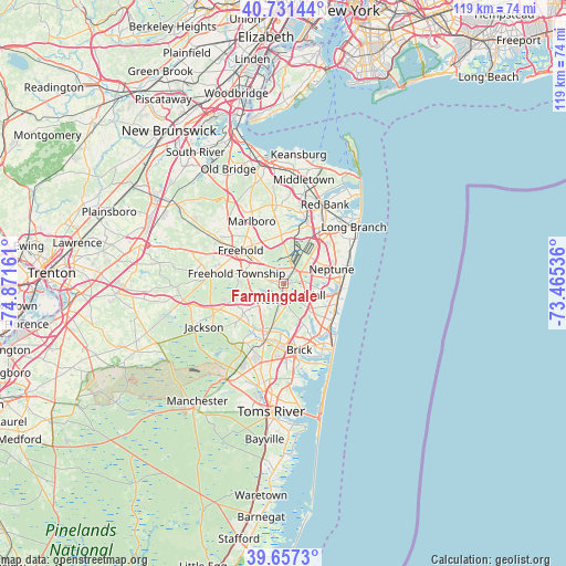
Farmingdale GPS coordinates[2]
40° 11' 47.4" North, 74° 10' 6.528" West
| Map corner | latitude | longitude |
|---|---|---|
| Upper-left | 40.73144°, | -74.87161° |
| Center: | 40.1965°, | -74.16848° |
| Lower-right: | 39.6573°, | -73.46536° |
| Map W x H: | 119.4×119.4 km | = 74.2×74.2mi |
| max Lat: | 71.29058° ⇑44.5% North |
| Farmingdale: | 40.1965° |
| min Lat: | ⇓55.5% South 19.06759° |
| min Long | Farmingdale | max Long |
| -171.73463° | -74.16848° | -66.98998° |
| W 89.6%⇐ | ⇒10.4% E |
Elevation
Elevation of Farmingdale is 25 m = 82 ft, and this is 269.8 m = 885 ft below average elevation for this country.
| Max E: |
3189 m = 10463 ft | 86.2% |
| Avg. | 294.8 m = 967 ft | |
| Farmingdale | 25 m = 82 ft | |
Min E: |
-60 m = -197 ft | 13.8% |
See also: United States elevation on elevation.city.
Geographical zone
Farmingdale is located in North temperate zone (between Tropic of Cancer and the Arctic Circle). Distance of this Northern Tropic circle is 1863.5 km =1157.9 mi to South.| Distance of | km | miles | from Farmingdale |
|---|---|---|---|
| North Pole | 5537.6 | 3440.9 | to North |
| Arctic Circle | 2931.7 | 1821.7 | to North |
| Tropic Cancer | 1863.5 | 1157.9 | to South |
| Equator | 4469.4 | 2777.2 | to South |


Nearby cities:
15 places around Farmingdale: (largest is in red/bold)
• Allenwood
8.4 km =5.2 mi,  136°
136°
• Belmar
12.6 km =7.8 mi,  99°
99°
• East Freehold
11.7 km =7.3 mi,  323°
323°
• Freehold
11.4 km =7.1 mi,  308°
308°
• Lake Como
12.6 km =7.8 mi,  108°
108°
• Lakewood
11.7 km =7.3 mi,  200°
200°
• Neptune City
11.9 km =7.4 mi,  88°
88°
• Ramtown
8.7 km =5.4 mi,  165°
165°
• Shark River Hills
10.2 km =6.3 mi, 91°
• South Belmar
12.3 km =7.6 mi, 103°
• Spring Lake
12.8 km =8 mi, 111°
• Spring Lake Heights
12.8 km =8 mi, 113°
• Wanamassa
12.8 km =8 mi,  72°
72°
• West Belmar
11.7 km =7.3 mi, 104°
• West Freehold
12.4 km =7.7 mi,  294°
294°
Sources, notices
• [Note1] Compared only with cities in United States existing in our database
• [Src1] Map data: © OpenStreetMap contributors (CC-BY-SA)
• [Src2] Other city data from geonames.org with taken over terms of usage.
• [Src3] Geographical zone / Annual Mean Temperature by Robert A. Rohde @ Wikipedia
