Freehold geodata
Freehold (New Jersey) is a seat of a second-order administrative division; located in United States in America/New_York (GMT-4) time zone. With population of 11,959 people, there are 3913 cities with bigger population in this country. Compared to other cities in United States, 56.1% of cities are located further ↓South; 89.2% of cities are located further ←West and 77.5% of cities have higher elevation than Freehold. Note1
Administrative division(s):
- Level 1: New Jersey
- Level 2: Monmouth County
- Level 3: Borough of Freehold


Freehold GPS coordinates[2]
40° 15' 36.396" North, 74° 16' 25.536" West
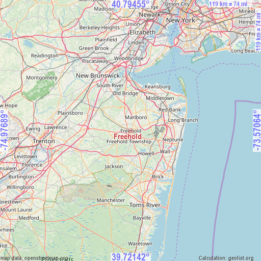
| Map corner | latitude | longitude |
|---|---|---|
| Upper-left | 40.79455°, | -74.97689° |
| Center: | 40.26011°, | -74.27376° |
| Lower-right: | 39.72142°, | -73.57064° |
| Map W x H: | 119.3×119.3 km | = 74.1×74.1mi |
| max Lat: | 71.29058° ⇑43.9% North |
| Freehold: | 40.26011° |
| min Lat: | ⇓56.1% South 19.06759° |
| min Long | Freehold | max Long |
| -171.73463° | -74.27376° | -66.98998° |
| W 89.2%⇐ | ⇒10.8% E |
Elevation
Elevation of Freehold is 58 m = 190 ft, and this is 236.8 m = 777 ft below average elevation for this country.
| Max E: |
3189 m = 10463 ft | 77.5% |
| Avg. | 294.8 m = 967 ft | |
| Freehold | 58 m = 190 ft | |
Min E: |
-60 m = -197 ft | 22.5% |
See also: United States elevation on elevation.city.
Geographical zone
Freehold is located in North temperate zone (between Tropic of Cancer and the Arctic Circle). Distance of this Northern Tropic circle is 1870.6 km =1162.3 mi to South.| Distance of | km | miles | from Freehold |
|---|---|---|---|
| North Pole | 5530.6 | 3436.6 | to North |
| Arctic Circle | 2924.7 | 1817.3 | to North |
| Tropic Cancer | 1870.6 | 1162.3 | to South |
| Equator | 4476.5 | 2781.6 | to South |


Nearby cities:
15 places around Freehold: (largest is in red/bold)
• Brownville
15.7 km =9.8 mi,  353°
353°
• Concordia
15.8 km =9.8 mi,  290°
290°
• East Freehold
3 km =1.9 mi,  39°
39°
• Englishtown
8.3 km =5.2 mi,  300°
300°
• Farmingdale
11.4 km =7.1 mi,  128°
128°
• Lincroft
15.1 km =9.4 mi,  58°
58°
• Marlboro
6.6 km =4.1 mi,  20°
20°
• Morganville
13.2 km =8.2 mi,  10°
10°
• Robertsville
9.6 km =6 mi, 352°
• Strathmore
15.9 km =9.9 mi, 18°
• Tinton Falls
15.5 km =9.6 mi,  71°
71°
• Vista Center
11.8 km =7.3 mi,  198°
198°
• West Freehold
3.1 km =1.9 mi,  229°
229°
• Whittingham
16.5 km =10.3 mi, 298°
• Yorketown
7.6 km =4.7 mi,  314°
314°
Sources, notices
• [Note1] Compared only with cities in United States existing in our database
• [Src1] Map data: © OpenStreetMap contributors (CC-BY-SA)
• [Src2] Other city data from geonames.org with taken over terms of usage.
• [Src3] Geographical zone / Annual Mean Temperature by Robert A. Rohde @ Wikipedia
