Hoboken geodata
Hoboken (New Jersey) is a populated place; located in United States in America/New_York (GMT-4) time zone. With population of 53,635 people, there are 870 cities with bigger population in this country. Compared to other cities in United States, 62.2% of cities are located further ↓South; 90.4% of cities are located further ←West and 98.1% of cities have higher elevation than Hoboken. Note1


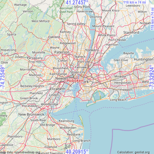
Hoboken GPS coordinates[2]
40° 44' 38.364" North, 74° 1' 56.496" West
| Map corner | latitude | longitude |
|---|---|---|
| Upper-left | 41.27457°, | -74.73549° |
| Center: | 40.74399°, | -74.03236° |
| Lower-right: | 40.20915°, | -73.32924° |
| Map W x H: | 118.5×118.5 km | = 73.6×73.6mi |
| max Lat: | 71.29058° ⇑37.8% North |
| Hoboken: | 40.74399° |
| min Lat: | ⇓62.2% South 19.06759° |
| min Long | Hoboken | max Long |
| -171.73463° | -74.03236° | -66.98998° |
| W 90.4%⇐ | ⇒9.6% E |
Elevation
Elevation of Hoboken is 5 m = 16 ft, and this is 289.8 m = 951 ft below average elevation for this country.
| Max E: |
3189 m = 10463 ft | 98.1% |
| Avg. | 294.8 m = 967 ft | |
| Hoboken | 5 m = 16 ft | |
Min E: |
-60 m = -197 ft | 1.9% |
See also: Hoboken elevation on elevation.city.
Geographical zone
Hoboken is located in North temperate zone (between Tropic of Cancer and the Arctic Circle). Distance of this Northern Tropic circle is 1924.4 km =1195.8 mi to South.| Distance of | km | miles | from Hoboken |
|---|---|---|---|
| North Pole | 5476.8 | 3403.1 | to North |
| Arctic Circle | 2870.9 | 1783.9 | to North |
| Tropic Cancer | 1924.4 | 1195.8 | to South |
| Equator | 4530.3 | 2815 | to South |


Nearby cities:
15 places around Hoboken: (largest is in red/bold)
• Brooklyn Heights
6.3 km =3.9 mi,  148°
148°
• East Village
4.1 km =2.5 mi,  113°
113°
• Financial District
4.5 km =2.8 mi, 153°
• Gramercy Park
4 km =2.5 mi,  100°
100°
• Guttenberg
5.9 km =3.7 mi,  24°
24°
• Hell's Kitchen
4.2 km =2.6 mi,  56°
56°
• Jersey City
4.2 km =2.6 mi,  245°
245°
• Long Island City
7 km =4.3 mi,  89°
89°
• Manhattan
7.1 km =4.4 mi,  51°
51°
• New York City
4 km =2.5 mi, 146°
• North Bergen
6.9 km =4.3 mi,  14°
14°
• Secaucus
5.5 km =3.4 mi,  338°
338°
• Union City
4 km =2.5 mi, 10°
• Weehawken
3 km =1.9 mi, 19°
• West New York
5.1 km =3.2 mi, 17°
Sources, notices
• [Note1] Compared only with cities in United States existing in our database
• [Src1] Map data: © OpenStreetMap contributors (CC-BY-SA)
• [Src2] Other city data from geonames.org with taken over terms of usage.
• [Src3] Geographical zone / Annual Mean Temperature by Robert A. Rohde @ Wikipedia
