Manhattan geodata
Manhattan (New York) is a seat of a second-order administrative division; located in United States in America/New_York (GMT-4) time zone. With population of 1,487,536 people, there are 8 cities with bigger population in this country. Compared to other cities in United States, 62.9% of cities are located further ↓South; 90.8% of cities are located further ←West and 82.1% of cities have higher elevation than Manhattan. Note1


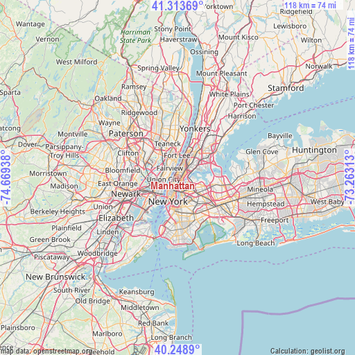
Manhattan GPS coordinates[2]
40° 47' 0.348" North, 73° 57' 58.5" West
| Map corner | latitude | longitude |
|---|---|---|
| Upper-left | 41.31369°, | -74.66938° |
| Center: | 40.78343°, | -73.96625° |
| Lower-right: | 40.2489°, | -73.26313° |
| Map W x H: | 118.4×118.4 km | = 73.6×73.6mi |
| max Lat: | 71.29058° ⇑37.1% North |
| Manhattan: | 40.78343° |
| min Lat: | ⇓62.9% South 19.06759° |
| min Long | Manhattan | max Long |
| -171.73463° | -73.96625° | -66.98998° |
| W 90.8%⇐ | ⇒9.2% E |
Elevation
Elevation of Manhattan is 38 m = 125 ft, and this is 256.8 m = 843 ft below average elevation for this country.
| Max E: |
3189 m = 10463 ft | 82.1% |
| Avg. | 294.8 m = 967 ft | |
| Manhattan | 38 m = 125 ft | |
Min E: |
-60 m = -197 ft | 17.9% |
See also: Manhattan elevation on elevation.city.
Geographical zone
Manhattan is located in North temperate zone (between Tropic of Cancer and the Arctic Circle). Distance of this Northern Tropic circle is 1928.8 km =1198.5 mi to South.| Distance of | km | miles | from Manhattan |
|---|---|---|---|
| North Pole | 5472.4 | 3400.4 | to North |
| Arctic Circle | 2866.5 | 1781.2 | to North |
| Tropic Cancer | 1928.8 | 1198.5 | to South |
| Equator | 4534.7 | 2817.7 | to South |


Nearby cities:
15 places around Manhattan: (largest is in red/bold)
• Astoria
3.3 km =2.1 mi,  112°
112°
• Cliffside Park
4.6 km =2.9 mi,  336°
336°
• East Harlem
2.4 km =1.5 mi,  57°
57°
• Edgewater
4.9 km =3 mi,  350°
350°
• Fairview
4.3 km =2.7 mi,  319°
319°
• Guttenberg
3.3 km =2.1 mi,  286°
286°
• Harlem
3.2 km =2 mi,  32°
32°
• Hell's Kitchen
2.9 km =1.8 mi,  225°
225°
• Long Island City
4.5 km =2.8 mi,  161°
161°
• Morningside Heights
3 km =1.9 mi,  6°
6°
• Mott Haven
4.6 km =2.9 mi,  52°
52°
• North Bergen
4.5 km =2.8 mi,  300°
300°
• Union City
4.9 km =3 mi,  264°
264°
• Weehawken
4.8 km =3 mi,  251°
251°
• West New York
4.1 km =2.5 mi,  276°
276°
Sources, notices
• [Note1] Compared only with cities in United States existing in our database
• [Src1] Map data: © OpenStreetMap contributors (CC-BY-SA)
• [Src2] Other city data from geonames.org with taken over terms of usage.
• [Src3] Geographical zone / Annual Mean Temperature by Robert A. Rohde @ Wikipedia
