Morristown geodata
Morristown (New Jersey) is a seat of a second-order administrative division; located in United States in America/New_York (GMT-4) time zone. With population of 18,594 people, there are 2704 cities with bigger population in this country. Compared to other cities in United States, 63.1% of cities are located further ↓South; 88.6% of cities are located further ←West and 66.4% of cities have higher elevation than Morristown. Note1


Morristown GPS coordinates[2]
40° 47' 48.372" North, 74° 28' 53.544" West
| Map corner | latitude | longitude |
|---|---|---|
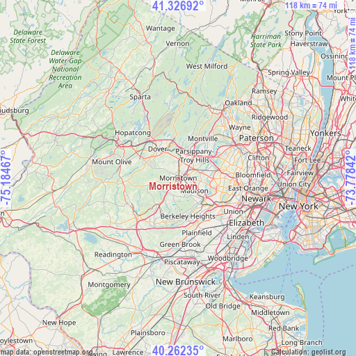
| Upper-left | 41.32692°, | -75.18467° |
| Center: | 40.79677°, | -74.48154° |
| Lower-right: | 40.26235°, | -73.77842° |
| Map W x H: | 118.4×118.4 km | = 73.6×73.6mi |
| max Lat: | 71.29058° ⇑36.9% North |
| Morristown: | 40.79677° |
| min Lat: | ⇓63.1% South 19.06759° |
| min Long | Morristown | max Long |
| -171.73463° | -74.48154° | -66.98998° |
| W 88.6%⇐ | ⇒11.4% E |
Elevation
Elevation of Morristown is 121 m = 397 ft, and this is 173.8 m = 570 ft below average elevation for this country.
| Max E: |
3189 m = 10463 ft | 66.4% |
| Avg. | 294.8 m = 967 ft | |
| Morristown | 121 m = 397 ft | |
Min E: |
-60 m = -197 ft | 33.6% |
See also: United States elevation on elevation.city.
Geographical zone
Morristown is located in North temperate zone (between Tropic of Cancer and the Arctic Circle). Distance of this Northern Tropic circle is 1930.3 km =1199.4 mi to South.| Distance of | km | miles | from Morristown |
|---|---|---|---|
| North Pole | 5470.9 | 3399.5 | to North |
| Arctic Circle | 2865 | 1780.2 | to North |
| Tropic Cancer | 1930.3 | 1199.4 | to South |
| Equator | 4536.2 | 2818.7 | to South |


Nearby cities:
15 places around Morristown: (largest is in red/bold)
• Bernardsville
11.4 km =7.1 mi,  220°
220°
• Chatham
10.3 km =6.4 mi,  127°
127°
• Dover
11.8 km =7.3 mi,  325°
325°
• East Hanover
10.2 km =6.3 mi,  75°
75°
• Florham Park
7.9 km =4.9 mi,  97°
97°
• Hanover
9.7 km =6 mi, 84°
• Madison
6.8 km =4.2 mi, 127°
• Mendham
10.3 km =6.4 mi,  256°
256°
• Morris Plains
2.8 km =1.7 mi,  0°
0°
• Mountain Lakes
11.6 km =7.2 mi,  20°
20°
• New Providence
12.8 km =8 mi,  148°
148°
• Parsippany
8.2 km =5.1 mi,  34°
34°
• Randolph
10.2 km =6.3 mi,  304°
304°
• Rockaway
11.9 km =7.4 mi,  346°
346°
• Victory Gardens
10.2 km =6.3 mi, 329°
Sources, notices
• [Note1] Compared only with cities in United States existing in our database
• [Src1] Map data: © OpenStreetMap contributors (CC-BY-SA)
• [Src2] Other city data from geonames.org with taken over terms of usage.
• [Src3] Geographical zone / Annual Mean Temperature by Robert A. Rohde @ Wikipedia
