Parsippany geodata
Parsippany (New Jersey) is a populated place; located in United States in America/New_York (GMT-4) time zone. With population of 51,144 people, there are 933 cities with bigger population in this country. Compared to other cities in United States, 64.1% of cities are located further ↓South; 88.7% of cities are located further ←West and 68.9% of cities have higher elevation than Parsippany. Note1
Administrative division(s):
- Level 1: New Jersey
- Level 2: Morris County
- Level 3: Township of Parsippany-Troy Hills


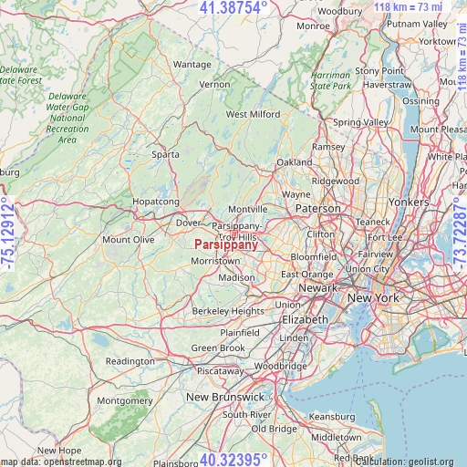
Parsippany GPS coordinates[2]
40° 51' 28.368" North, 74° 25' 33.564" West
| Map corner | latitude | longitude |
|---|---|---|
| Upper-left | 41.38754°, | -75.12912° |
| Center: | 40.85788°, | -74.42599° |
| Lower-right: | 40.32395°, | -73.72287° |
| Map W x H: | 118.3×118.3 km | = 73.5×73.5mi |
| max Lat: | 71.29058° ⇑35.9% North |
| Parsippany: | 40.85788° |
| min Lat: | ⇓64.1% South 19.06759° |
| min Long | Parsippany | max Long |
| -171.73463° | -74.42599° | -66.98998° |
| W 88.7%⇐ | ⇒11.3% E |
Elevation
Elevation of Parsippany is 107 m = 351 ft, and this is 187.8 m = 616 ft below average elevation for this country.
| Max E: |
3189 m = 10463 ft | 68.9% |
| Avg. | 294.8 m = 967 ft | |
| Parsippany | 107 m = 351 ft | |
Min E: |
-60 m = -197 ft | 31.1% |
See also: Parsippany elevation on elevation.city.
Geographical zone
Parsippany is located in North temperate zone (between Tropic of Cancer and the Arctic Circle). Distance of this Northern Tropic circle is 1937.1 km =1203.7 mi to South.| Distance of | km | miles | from Parsippany |
|---|---|---|---|
| North Pole | 5464.1 | 3395.2 | to North |
| Arctic Circle | 2858.2 | 1776 | to North |
| Tropic Cancer | 1937.1 | 1203.7 | to South |
| Equator | 4543 | 2822.9 | to South |


Nearby cities:
15 places around Parsippany: (largest is in red/bold)
• Boonton
5.2 km =3.2 mi,  17°
17°
• East Hanover
6.6 km =4.1 mi,  129°
129°
• Fairfield
10.5 km =6.5 mi,  74°
74°
• Florham Park
8.4 km =5.2 mi,  157°
157°
• Hanover
7.7 km =4.8 mi,  139°
139°
• Livingston
11.6 km =7.2 mi, 126°
• Madison
10.9 km =6.8 mi,  176°
176°
• Morris Plains
6.1 km =3.8 mi,  229°
229°
• Morristown
8.2 km =5.1 mi,  214°
214°
• Mountain Lakes
4.1 km =2.5 mi,  351°
351°
• Rockaway
8.9 km =5.5 mi,  302°
302°
• Victory Gardens
10 km =6.2 mi,  281°
281°
• West Caldwell
10.9 km =6.8 mi,  95°
95°
• Westville
10.7 km =6.6 mi, 97°
• White Meadow Lake
10.2 km =6.3 mi,  315°
315°
Sources, notices
• [Note1] Compared only with cities in United States existing in our database
• [Src1] Map data: © OpenStreetMap contributors (CC-BY-SA)
• [Src2] Other city data from geonames.org with taken over terms of usage.
• [Src3] Geographical zone / Annual Mean Temperature by Robert A. Rohde @ Wikipedia
