Paterson geodata
Paterson (New Jersey) is a seat of a second-order administrative division; located in United States in America/New_York (GMT-4) time zone. With population of 147,754 people, there are 202 cities with bigger population in this country. Compared to other cities in United States, 64.9% of cities are located further ↓South; 89.6% of cities are located further ←West and 82.9% of cities have higher elevation than Paterson. Note1


Paterson GPS coordinates[2]
40° 55' 0.372" North, 74° 10' 18.516" West
| Map corner | latitude | longitude |
|---|---|---|
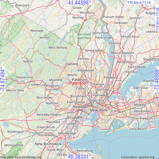
| Upper-left | 41.44596°, | -74.87494° |
| Center: | 40.91677°, | -74.17181° |
| Lower-right: | 40.38331°, | -73.46869° |
| Map W x H: | 118.2×118.2 km | = 73.4×73.4mi |
| max Lat: | 71.29058° ⇑35.1% North |
| Paterson: | 40.91677° |
| min Lat: | ⇓64.9% South 19.06759° |
| min Long | Paterson | max Long |
| -171.73463° | -74.17181° | -66.98998° |
| W 89.6%⇐ | ⇒10.4% E |
Elevation
Elevation of Paterson is 35 m = 115 ft, and this is 259.8 m = 852 ft below average elevation for this country.
| Max E: |
3189 m = 10463 ft | 82.9% |
| Avg. | 294.8 m = 967 ft | |
| Paterson | 35 m = 115 ft | |
Min E: |
-60 m = -197 ft | 17.1% |
See also: Paterson elevation on elevation.city.
Geographical zone
Paterson is located in North temperate zone (between Tropic of Cancer and the Arctic Circle). Distance of this Northern Tropic circle is 1943.6 km =1207.7 mi to South.| Distance of | km | miles | from Paterson |
|---|---|---|---|
| North Pole | 5457.5 | 3391.1 | to North |
| Arctic Circle | 2851.7 | 1772 | to North |
| Tropic Cancer | 1943.6 | 1207.7 | to South |
| Equator | 4549.5 | 2826.9 | to South |


Nearby cities:
15 places around Paterson: (largest is in red/bold)
• Clifton
6.5 km =4 mi,  174°
174°
• Elmwood Park
4.7 km =2.9 mi,  107°
107°
• Fair Lawn
4.3 km =2.7 mi,  52°
52°
• Garfield
6.3 km =3.9 mi,  128°
128°
• Glen Rock
6.1 km =3.8 mi,  32°
32°
• Haledon
2.4 km =1.5 mi,  329°
329°
• Hawthorne
3.9 km =2.4 mi,  22°
22°
• Little Falls
6.1 km =3.8 mi,  209°
209°
• North Haledon
4.4 km =2.7 mi,  344°
344°
• Passaic
7.6 km =4.7 mi,  151°
151°
• Prospect Park
2.3 km =1.4 mi,  354°
354°
• Saddle Brook
6.9 km =4.3 mi, 106°
• Singac
6.7 km =4.2 mi,  240°
240°
• Totowa
3.5 km =2.2 mi,  247°
247°
• Woodland Park
3.6 km =2.2 mi, 212°
Sources, notices
• [Note1] Compared only with cities in United States existing in our database
• [Src1] Map data: © OpenStreetMap contributors (CC-BY-SA)
• [Src2] Other city data from geonames.org with taken over terms of usage.
• [Src3] Geographical zone / Annual Mean Temperature by Robert A. Rohde @ Wikipedia
