Pennington geodata
Pennington (New Jersey) is a populated place; located in United States in America/New_York (GMT-4) time zone. With population of 2,598 people, there are 10400 cities with bigger population in this country. Compared to other cities in United States, 57% of cities are located further ↓South; 87.9% of cities are located further ←West and 75.5% of cities have higher elevation than Pennington. Note1
Administrative division(s):
- Level 1: New Jersey
- Level 2: Mercer County
- Level 3: Borough of Pennington


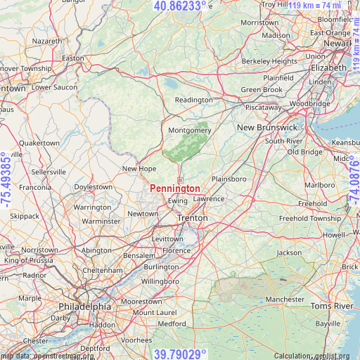
Pennington GPS coordinates[2]
40° 19' 42.384" North, 74° 47' 26.592" West
| Map corner | latitude | longitude |
|---|---|---|
| Upper-left | 40.86233°, | -75.49385° |
| Center: | 40.32844°, | -74.79072° |
| Lower-right: | 39.79029°, | -74.0876° |
| Map W x H: | 119.2×119.2 km | = 74.1×74.1mi |
| max Lat: | 71.29058° ⇑43% North |
| Pennington: | 40.32844° |
| min Lat: | ⇓57% South 19.06759° |
| min Long | Pennington | max Long |
| -171.73463° | -74.79072° | -66.98998° |
| W 87.9%⇐ | ⇒12.1% E |
Elevation
Elevation of Pennington is 69 m = 226 ft, and this is 225.8 m = 741 ft below average elevation for this country.
| Max E: |
3189 m = 10463 ft | 75.5% |
| Avg. | 294.8 m = 967 ft | |
| Pennington | 69 m = 226 ft | |
Min E: |
-60 m = -197 ft | 24.5% |
See also: United States elevation on elevation.city.
Geographical zone
Pennington is located in North temperate zone (between Tropic of Cancer and the Arctic Circle). Distance of this Northern Tropic circle is 1878.2 km =1167.1 mi to South.| Distance of | km | miles | from Pennington |
|---|---|---|---|
| North Pole | 5523 | 3431.8 | to North |
| Arctic Circle | 2917.1 | 1812.6 | to North |
| Tropic Cancer | 1878.2 | 1167.1 | to South |
| Equator | 4484.1 | 2786.3 | to South |


Nearby cities:
15 places around Pennington: (largest is in red/bold)
• Ewing
6.6 km =4.1 mi,  186°
186°
• Hopewell
7.2 km =4.5 mi,  19°
19°
• Lambertville
13.6 km =8.5 mi,  287°
287°
• Lawrenceville
6.2 km =3.9 mi,  123°
123°
• Mercerville
13.5 km =8.4 mi,  138°
138°
• Mercerville-Hamilton Square
14.8 km =9.2 mi, 137°
• Morrisville
13 km =8.1 mi,  178°
178°
• New Hope
14.2 km =8.8 mi, 286°
• Princeton
11.4 km =7.1 mi,  78°
78°
• Princeton Junction
14.5 km =9 mi,  94°
94°
• Prospect Park
10 km =6.2 mi,  168°
168°
• Rocky Hill
15.4 km =9.6 mi,  59°
59°
• Trenton
13 km =8.1 mi,  161°
161°
• Woodside
13.9 km =8.6 mi,  211°
211°
• Yardley
10.3 km =6.4 mi, 206°
Sources, notices
• [Note1] Compared only with cities in United States existing in our database
• [Src1] Map data: © OpenStreetMap contributors (CC-BY-SA)
• [Src2] Other city data from geonames.org with taken over terms of usage.
• [Src3] Geographical zone / Annual Mean Temperature by Robert A. Rohde @ Wikipedia
