Trenton geodata
Trenton (New Jersey) is a seat of a first-order administrative division; located in United States in America/New_York (GMT-4) time zone. With population of 84,225 people, there are 461 cities with bigger population in this country. Compared to other cities in United States, 55.7% of cities are located further ↓South; 88% of cities are located further ←West and 87% of cities have higher elevation than Trenton. Note1


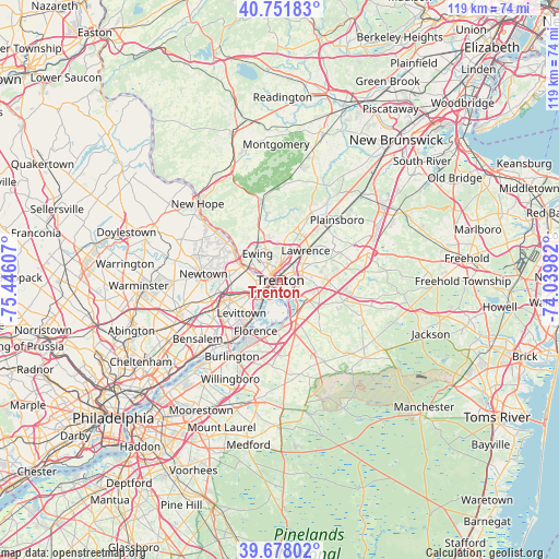
Trenton GPS coordinates[2]
40° 13' 1.38" North, 74° 44' 34.584" West
| Map corner | latitude | longitude |
|---|---|---|
| Upper-left | 40.75183°, | -75.44607° |
| Center: | 40.21705°, | -74.74294° |
| Lower-right: | 39.67802°, | -74.03982° |
| Map W x H: | 119.4×119.4 km | = 74.2×74.2mi |
| max Lat: | 71.29058° ⇑44.3% North |
| Trenton: | 40.21705° |
| min Lat: | ⇓55.7% South 19.06759° |
| min Long | Trenton | max Long |
| -171.73463° | -74.74294° | -66.98998° |
| W 88%⇐ | ⇒12% E |
Elevation
Elevation of Trenton is 23 m = 75 ft, and this is 271.8 m = 892 ft below average elevation for this country.
| Max E: |
3189 m = 10463 ft | 87% |
| Avg. | 294.8 m = 967 ft | |
| Trenton | 23 m = 75 ft | |
Min E: |
-60 m = -197 ft | 13% |
See also: Trenton elevation on elevation.city.
Geographical zone
Trenton is located in North temperate zone (between Tropic of Cancer and the Arctic Circle). Distance of this Northern Tropic circle is 1865.8 km =1159.4 mi to South.| Distance of | km | miles | from Trenton |
|---|---|---|---|
| North Pole | 5535.3 | 3439.5 | to North |
| Arctic Circle | 2929.5 | 1820.3 | to North |
| Tropic Cancer | 1865.8 | 1159.4 | to South |
| Equator | 4471.7 | 2778.6 | to South |


Nearby cities:
15 places around Trenton: (largest is in red/bold)
• Bordentown
8.3 km =5.2 mi,  161°
161°
• Ewing
7.6 km =4.7 mi,  320°
320°
• Fairless Hills
10.4 km =6.5 mi,  246°
246°
• Fieldsboro
9 km =5.6 mi,  172°
172°
• Groveville
8 km =5 mi,  130°
130°
• Hamilton Square
7.7 km =4.8 mi,  81°
81°
• Lawrenceville
9 km =5.6 mi,  7°
7°
• Levittown
10 km =6.2 mi,  226°
226°
• Mercerville
5.3 km =3.3 mi,  65°
65°
• Mercerville-Hamilton Square
6.2 km =3.9 mi, 75°
• Morrisville
3.9 km =2.4 mi,  260°
260°
• Prospect Park
3.3 km =2.1 mi, 322°
• White Horse
4.5 km =2.8 mi, 130°
• Yardley
9.3 km =5.8 mi,  289°
289°
• Yardville
7.8 km =4.8 mi,  120°
120°
Sources, notices
• [Note1] Compared only with cities in United States existing in our database
• [Src1] Map data: © OpenStreetMap contributors (CC-BY-SA)
• [Src2] Other city data from geonames.org with taken over terms of usage.
• [Src3] Geographical zone / Annual Mean Temperature by Robert A. Rohde @ Wikipedia
