Ringwood geodata
Ringwood (New Jersey) is a populated place; located in United States in America/New_York (GMT-4) time zone. With population of 12,448 people, there are 3785 cities with bigger population in this country. Compared to other cities in United States, 67% of cities are located further ↓South; 89.3% of cities are located further ←West and 60.1% of cities have higher elevation than Ringwood. Note1
Administrative division(s):
- Level 1: New Jersey
- Level 2: Passaic County
- Level 3: Borough of Ringwood


Ringwood GPS coordinates[2]
41° 6' 48.348" North, 74° 14' 43.548" West
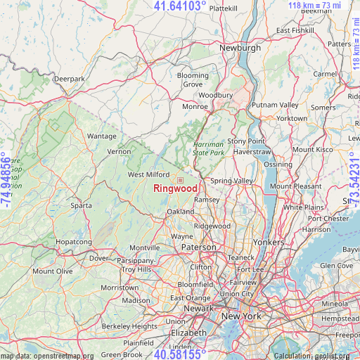
| Map corner | latitude | longitude |
|---|---|---|
| Upper-left | 41.64103°, | -74.94856° |
| Center: | 41.11343°, | -74.24543° |
| Lower-right: | 40.58155°, | -73.54231° |
| Map W x H: | 117.8×117.8 km | = 73.2×73.2mi |
| max Lat: | 71.29058° ⇑33% North |
| Ringwood: | 41.11343° |
| min Lat: | ⇓67% South 19.06759° |
| min Long | Ringwood | max Long |
| -171.73463° | -74.24543° | -66.98998° |
| W 89.3%⇐ | ⇒10.7% E |
Elevation
Elevation of Ringwood is 154 m = 505 ft, and this is 140.8 m = 462 ft below average elevation for this country.
| Max E: |
3189 m = 10463 ft | 60.1% |
| Avg. | 294.8 m = 967 ft | |
| Ringwood | 154 m = 505 ft | |
Min E: |
-60 m = -197 ft | 39.9% |
See also: United States elevation on elevation.city.
Geographical zone
Ringwood is located in North temperate zone (between Tropic of Cancer and the Arctic Circle). Distance of this Northern Tropic circle is 1965.5 km =1221.3 mi to South.| Distance of | km | miles | from Ringwood |
|---|---|---|---|
| North Pole | 5435.7 | 3377.6 | to North |
| Arctic Circle | 2829.8 | 1758.4 | to North |
| Tropic Cancer | 1965.5 | 1221.3 | to South |
| Equator | 4571.4 | 2840.5 | to South |


Nearby cities:
15 places around Ringwood: (largest is in red/bold)
• Airmont
10.9 km =6.8 mi,  97°
97°
• Allendale
12.6 km =7.8 mi,  129°
129°
• Franklin Lakes
11.3 km =7 mi,  162°
162°
• Greenwood Lake
12.8 km =8 mi,  341°
341°
• Hillburn
6.5 km =4 mi,  79°
79°
• Mahwah
9 km =5.6 mi,  107°
107°
• Montebello
10.9 km =6.8 mi, 76°
• Oakland
11.3 km =7 mi,  188°
188°
• Pompton Lakes
12.6 km =7.8 mi,  197°
197°
• Ramsey
10.7 km =6.6 mi, 125°
• Sloatsburg
6.3 km =3.9 mi,  43°
43°
• Suffern
8 km =5 mi,  88°
88°
• Tuxedo Park
10.3 km =6.4 mi,  29°
29°
• Wanaque
9.3 km =5.8 mi,  205°
205°
• West Milford
10.4 km =6.5 mi,  280°
280°
Sources, notices
• [Note1] Compared only with cities in United States existing in our database
• [Src1] Map data: © OpenStreetMap contributors (CC-BY-SA)
• [Src2] Other city data from geonames.org with taken over terms of usage.
• [Src3] Geographical zone / Annual Mean Temperature by Robert A. Rohde @ Wikipedia
