West Milford geodata
West Milford (New Jersey) is a populated place; located in United States in America/New_York (GMT-4) time zone. With population of 26,968 people, there are 1860 cities with bigger population in this country. Compared to other cities in United States, 67.2% of cities are located further ↓South; 88.8% of cities are located further ←West and 53.9% of cities have lower elevation than West Milford. Note1
Administrative division(s):
- Level 1: New Jersey
- Level 2: Passaic County
- Level 3: Township of West Milford


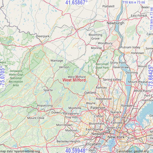
West Milford GPS coordinates[2]
41° 7' 52.356" North, 74° 22' 2.532" West
| Map corner | latitude | longitude |
|---|---|---|
| Upper-left | 41.65867°, | -75.0705° |
| Center: | 41.13121°, | -74.36737° |
| Lower-right: | 40.59948°, | -73.66425° |
| Map W x H: | 117.8×117.8 km | = 73.2×73.2mi |
| max Lat: | 71.29058° ⇑32.8% North |
| West Milford: | 41.13121° |
| min Lat: | ⇓67.2% South 19.06759° |
| min Long | West Milford | max Long |
| -171.73463° | -74.36737° | -66.98998° |
| W 88.8%⇐ | ⇒11.2% E |
Elevation
Elevation of West Milford is 214 m = 702 ft, and this is 80.8 m = 265 ft below average elevation for this country.
| Max E: |
3189 m = 10463 ft | 46.1% |
| Avg. | 294.8 m = 967 ft | |
| West Milford | 214 m = 702 ft | |
Min E: |
-60 m = -197 ft | 53.9% |
See also: United States elevation on elevation.city.
Geographical zone
West Milford is located in North temperate zone (between Tropic of Cancer and the Arctic Circle). Distance of this Northern Tropic circle is 1967.4 km =1222.5 mi to South.| Distance of | km | miles | from West Milford |
|---|---|---|---|
| North Pole | 5433.7 | 3376.3 | to North |
| Arctic Circle | 2827.8 | 1757.1 | to North |
| Tropic Cancer | 1967.4 | 1222.5 | to South |
| Equator | 4573.4 | 2841.8 | to South |


Nearby cities:
15 places around West Milford: (largest is in red/bold)
• Bloomingdale
14.8 km =9.2 mi,  166°
166°
• Butler
14.3 km =8.9 mi, 171°
• Greenwood Lake
11.9 km =7.4 mi,  31°
31°
• Highland Lake
9 km =5.6 mi,  304°
304°
• Hillburn
16.6 km =10.3 mi,  92°
92°
• Kinnelon
14.4 km =8.9 mi,  179°
179°
• Oakland
15.7 km =9.8 mi,  146°
146°
• Pompton Lakes
15.4 km =9.6 mi,  155°
155°
• Ringwood
10.4 km =6.5 mi,  100°
100°
• Riverdale
16.2 km =10.1 mi, 160°
• Sloatsburg
14.8 km =9.2 mi,  79°
79°
• Vernon Center
13.1 km =8.1 mi, 299°
• Vernon Valley
15.4 km =9.6 mi,  319°
319°
• Wanaque
12 km =7.5 mi, 149°
• Warwick
13.9 km =8.6 mi,  2°
2°
Sources, notices
• [Note1] Compared only with cities in United States existing in our database
• [Src1] Map data: © OpenStreetMap contributors (CC-BY-SA)
• [Src2] Other city data from geonames.org with taken over terms of usage.
• [Src3] Geographical zone / Annual Mean Temperature by Robert A. Rohde @ Wikipedia
