River Edge geodata
River Edge (New Jersey) is a populated place; located in United States in America/New_York (GMT-4) time zone. With population of 11,668 people, there are 3976 cities with bigger population in this country. Compared to other cities in United States, 65.1% of cities are located further ↓South; 90.3% of cities are located further ←West and 87% of cities have higher elevation than River Edge. Note1
Administrative division(s):
- Level 1: New Jersey
- Level 2: Bergen County
- Level 3: Borough of River Edge


River Edge GPS coordinates[2]
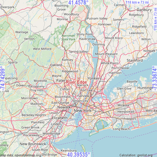
40° 55' 43.356" North, 74° 2' 23.496" West
| Map corner | latitude | longitude |
|---|---|---|
| Upper-left | 41.4578°, | -74.74299° |
| Center: | 40.92871°, | -74.03986° |
| Lower-right: | 40.39535°, | -73.33674° |
| Map W x H: | 118.1×118.1 km | = 73.4×73.4mi |
| max Lat: | 71.29058° ⇑34.9% North |
| River Edge: | 40.92871° |
| min Lat: | ⇓65.1% South 19.06759° |
| min Long | River Edge | max Long |
| -171.73463° | -74.03986° | -66.98998° |
| W 90.3%⇐ | ⇒9.7% E |
Elevation
Elevation of River Edge is 23 m = 75 ft, and this is 271.8 m = 892 ft below average elevation for this country.
| Max E: |
3189 m = 10463 ft | 87% |
| Avg. | 294.8 m = 967 ft | |
| River Edge | 23 m = 75 ft | |
Min E: |
-60 m = -197 ft | 13% |
See also: United States elevation on elevation.city.
Geographical zone
River Edge is located in North temperate zone (between Tropic of Cancer and the Arctic Circle). Distance of this Northern Tropic circle is 1944.9 km =1208.5 mi to South.| Distance of | km | miles | from River Edge |
|---|---|---|---|
| North Pole | 5456.2 | 3390.3 | to North |
| Arctic Circle | 2850.3 | 1771.1 | to North |
| Tropic Cancer | 1944.9 | 1208.5 | to South |
| Equator | 4550.8 | 2827.7 | to South |


Nearby cities:
15 places around River Edge: (largest is in red/bold)
• Bergenfield
3.6 km =2.2 mi,  91°
91°
• Bogota
5.9 km =3.7 mi,  171°
171°
• Dumont
3.9 km =2.4 mi,  69°
69°
• Emerson
5.4 km =3.4 mi,  12°
12°
• Hackensack
4.8 km =3 mi,  183°
183°
• Haworth
5.5 km =3.4 mi,  49°
49°
• Lodi
6.3 km =3.9 mi,  215°
215°
• Maywood
3.4 km =2.1 mi,  212°
212°
• New Milford
1.9 km =1.2 mi, 67°
• Oradell
3.3 km =2.1 mi,  4°
4°
• Paramus
3.5 km =2.2 mi,  300°
300°
• Rochelle Park
3.8 km =2.4 mi,  231°
231°
• Saddle Brook
5.5 km =3.4 mi, 233°
• Teaneck
4 km =2.5 mi,  149°
149°
• Tenafly
6.5 km =4 mi, 93°
Sources, notices
• [Note1] Compared only with cities in United States existing in our database
• [Src1] Map data: © OpenStreetMap contributors (CC-BY-SA)
• [Src2] Other city data from geonames.org with taken over terms of usage.
• [Src3] Geographical zone / Annual Mean Temperature by Robert A. Rohde @ Wikipedia
