Hackensack geodata
Hackensack (New Jersey) is a seat of a second-order administrative division; located in United States in America/New_York (GMT-4) time zone. With population of 44,834 people, there are 1063 cities with bigger population in this country. Compared to other cities in United States, 64.5% of cities are located further ↓South; 90.3% of cities are located further ←West and 95.7% of cities have higher elevation than Hackensack. Note1


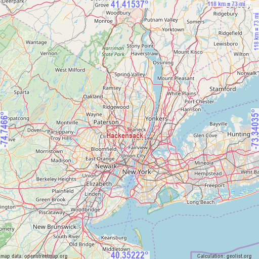
Hackensack GPS coordinates[2]
40° 53' 9.348" North, 74° 2' 36.492" West
| Map corner | latitude | longitude |
|---|---|---|
| Upper-left | 41.41537°, | -74.7466° |
| Center: | 40.88593°, | -74.04347° |
| Lower-right: | 40.35222°, | -73.34035° |
| Map W x H: | 118.2×118.2 km | = 73.4×73.4mi |
| max Lat: | 71.29058° ⇑35.5% North |
| Hackensack: | 40.88593° |
| min Lat: | ⇓64.5% South 19.06759° |
| min Long | Hackensack | max Long |
| -171.73463° | -74.04347° | -66.98998° |
| W 90.3%⇐ | ⇒9.7% E |
Elevation
Elevation of Hackensack is 8 m = 26 ft, and this is 286.8 m = 941 ft below average elevation for this country.
| Max E: |
3189 m = 10463 ft | 95.7% |
| Avg. | 294.8 m = 967 ft | |
| Hackensack | 8 m = 26 ft | |
Min E: |
-60 m = -197 ft | 4.3% |
See also: Hackensack elevation on elevation.city.
Geographical zone
Hackensack is located in North temperate zone (between Tropic of Cancer and the Arctic Circle). Distance of this Northern Tropic circle is 1940.2 km =1205.6 mi to South.| Distance of | km | miles | from Hackensack |
|---|---|---|---|
| North Pole | 5461 | 3393.3 | to North |
| Arctic Circle | 2855.1 | 1774.1 | to North |
| Tropic Cancer | 1940.2 | 1205.6 | to South |
| Equator | 4546.1 | 2824.8 | to South |


Nearby cities:
15 places around Hackensack: (largest is in red/bold)
• Bogota
1.6 km =1 mi,  133°
133°
• Hasbrouck Heights
4.4 km =2.7 mi,  225°
225°
• Leonia
5.4 km =3.4 mi,  120°
120°
• Little Ferry
3.7 km =2.3 mi,  178°
178°
• Lodi
3.4 km =2.1 mi,  263°
263°
• Maywood
2.4 km =1.5 mi,  320°
320°
• Moonachie
5 km =3.1 mi, 181°
• New Milford
5.8 km =3.6 mi,  20°
20°
• Palisades Park
5.7 km =3.5 mi,  137°
137°
• Ridgefield Park
3.7 km =2.3 mi,  150°
150°
• River Edge
4.8 km =3 mi,  3°
3°
• Rochelle Park
3.6 km =2.2 mi,  311°
311°
• Saddle Brook
4.4 km =2.7 mi,  289°
289°
• Teaneck
2.7 km =1.7 mi,  60°
60°
• Wood-Ridge
5.8 km =3.6 mi,  219°
219°
Sources, notices
• [Note1] Compared only with cities in United States existing in our database
• [Src1] Map data: © OpenStreetMap contributors (CC-BY-SA)
• [Src2] Other city data from geonames.org with taken over terms of usage.
• [Src3] Geographical zone / Annual Mean Temperature by Robert A. Rohde @ Wikipedia
