Union geodata
Union (New Jersey) is a populated place; located in United States in America/New_York (GMT-4) time zone. With population of 56,771 people, there are 805 cities with bigger population in this country. Compared to other cities in United States, 61.6% of cities are located further ↓South; 89.2% of cities are located further ←West and 82.9% of cities have higher elevation than Union. Note1


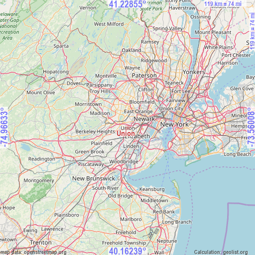
Union GPS coordinates[2]
40° 41' 51.36" North, 74° 15' 47.52" West
| Map corner | latitude | longitude |
|---|---|---|
| Upper-left | 41.22855°, | -74.96633° |
| Center: | 40.6976°, | -74.2632° |
| Lower-right: | 40.16239°, | -73.56008° |
| Map W x H: | 118.5×118.5 km | = 73.6×73.6mi |
| max Lat: | 71.29058° ⇑38.4% North |
| Union: | 40.6976° |
| min Lat: | ⇓61.6% South 19.06759° |
| min Long | Union | max Long |
| -171.73463° | -74.2632° | -66.98998° |
| W 89.2%⇐ | ⇒10.8% E |
Elevation
Elevation of Union is 35 m = 115 ft, and this is 259.8 m = 852 ft below average elevation for this country.
| Max E: |
3189 m = 10463 ft | 82.9% |
| Avg. | 294.8 m = 967 ft | |
| Union | 35 m = 115 ft | |
Min E: |
-60 m = -197 ft | 17.1% |
See also: Union elevation on elevation.city.
Geographical zone
Union is located in North temperate zone (between Tropic of Cancer and the Arctic Circle). Distance of this Northern Tropic circle is 1919.2 km =1192.5 mi to South.| Distance of | km | miles | from Union |
|---|---|---|---|
| North Pole | 5481.9 | 3406.3 | to North |
| Arctic Circle | 2876 | 1787.1 | to North |
| Tropic Cancer | 1919.2 | 1192.5 | to South |
| Equator | 4525.1 | 2811.8 | to South |


Nearby cities:
15 places around Union: (largest is in red/bold)
• Clark
7.5 km =4.7 mi,  212°
212°
• Cranford
5.3 km =3.3 mi,  215°
215°
• Elizabeth
5.8 km =3.6 mi,  130°
130°
• Garwood
7.2 km =4.5 mi, 224°
• Hillside
2.8 km =1.7 mi,  81°
81°
• Irvington
4.5 km =2.8 mi,  31°
31°
• Kenilworth
3.3 km =2.1 mi, 224°
• Maplewood
3.8 km =2.4 mi,  346°
346°
• Roselle
5.1 km =3.2 mi,  175°
175°
• Roselle Park
3.7 km =2.3 mi, 181°
• Short Hills
7.7 km =4.8 mi,  316°
316°
• South Orange
5.7 km =3.5 mi,  1°
1°
• Springfield
4.6 km =2.9 mi,  280°
280°
• Westfield
8.3 km =5.2 mi,  238°
238°
• Winfield
6.4 km =4 mi,  197°
197°
Sources, notices
• [Note1] Compared only with cities in United States existing in our database
• [Src1] Map data: © OpenStreetMap contributors (CC-BY-SA)
• [Src2] Other city data from geonames.org with taken over terms of usage.
• [Src3] Geographical zone / Annual Mean Temperature by Robert A. Rohde @ Wikipedia
