Irvington geodata
Irvington (New Jersey) is a populated place; located in United States in America/New_York (GMT-4) time zone. With population of 61,323 people, there are 716 cities with bigger population in this country. Compared to other cities in United States, 62.1% of cities are located further ↓South; 89.3% of cities are located further ←West and 79.7% of cities have higher elevation than Irvington. Note1
Administrative division(s):
- Level 1: New Jersey
- Level 2: Essex County
- Level 3: Township of Irvington


Irvington GPS coordinates[2]
40° 43' 56.352" North, 74° 14' 5.532" West
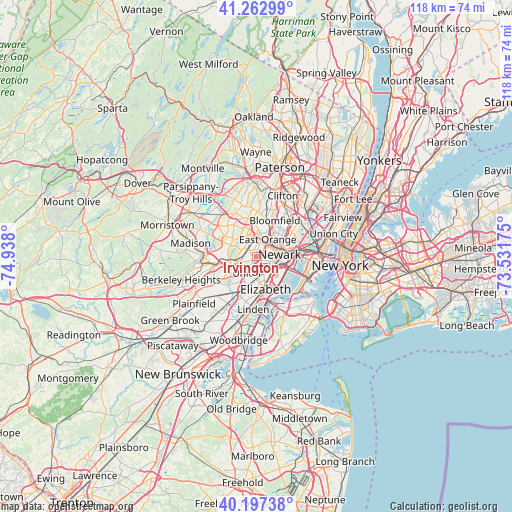
| Map corner | latitude | longitude |
|---|---|---|
| Upper-left | 41.26299°, | -74.938° |
| Center: | 40.73232°, | -74.23487° |
| Lower-right: | 40.19738°, | -73.53175° |
| Map W x H: | 118.5×118.5 km | = 73.6×73.6mi |
| max Lat: | 71.29058° ⇑37.9% North |
| Irvington: | 40.73232° |
| min Lat: | ⇓62.1% South 19.06759° |
| min Long | Irvington | max Long |
| -171.73463° | -74.23487° | -66.98998° |
| W 89.3%⇐ | ⇒10.7% E |
Elevation
Elevation of Irvington is 48 m = 157 ft, and this is 246.8 m = 810 ft below average elevation for this country.
| Max E: |
3189 m = 10463 ft | 79.7% |
| Avg. | 294.8 m = 967 ft | |
| Irvington | 48 m = 157 ft | |
Min E: |
-60 m = -197 ft | 20.3% |
See also: Irvington elevation on elevation.city.
Geographical zone
Irvington is located in North temperate zone (between Tropic of Cancer and the Arctic Circle). Distance of this Northern Tropic circle is 1923.1 km =1195 mi to South.| Distance of | km | miles | from Irvington |
|---|---|---|---|
| North Pole | 5478.1 | 3403.9 | to North |
| Arctic Circle | 2872.2 | 1784.7 | to North |
| Tropic Cancer | 1923.1 | 1195 | to South |
| Equator | 4529 | 2814.2 | to South |


Nearby cities:
15 places around Irvington: (largest is in red/bold)
• East Newark
6.4 km =4 mi,  73°
73°
• East Orange
4.6 km =2.9 mi,  32°
32°
• Elizabeth
7.9 km =4.9 mi,  164°
164°
• Harrison
6.8 km =4.2 mi,  76°
76°
• Hillside
3.5 km =2.2 mi,  173°
173°
• Kenilworth
7.8 km =4.8 mi,  217°
217°
• Maplewood
3.3 km =2.1 mi,  267°
267°
• Newark
5.3 km =3.3 mi,  85°
85°
• Orange
4.3 km =2.7 mi,  2°
2°
• Roselle Park
7.9 km =4.9 mi,  198°
198°
• Short Hills
7.8 km =4.8 mi,  282°
282°
• South Orange
2.9 km =1.8 mi,  309°
309°
• Springfield
7.6 km =4.7 mi,  246°
246°
• Union
4.5 km =2.8 mi,  211°
211°
• West Orange
7.4 km =4.6 mi,  357°
357°
Sources, notices
• [Note1] Compared only with cities in United States existing in our database
• [Src1] Map data: © OpenStreetMap contributors (CC-BY-SA)
• [Src2] Other city data from geonames.org with taken over terms of usage.
• [Src3] Geographical zone / Annual Mean Temperature by Robert A. Rohde @ Wikipedia
