Wood-Ridge geodata
Wood-Ridge (New Jersey) is a populated place; located in United States in America/New_York (GMT-4) time zone. With population of 8,249 people, there are 5170 cities with bigger population in this country. Compared to other cities in United States, 63.9% of cities are located further ↓South; 90% of cities are located further ←West and 78.4% of cities have higher elevation than Wood-Ridge. Note1
Administrative division(s):
- Level 1: New Jersey
- Level 2: Bergen County
- Level 3: Borough of Wood-Ridge


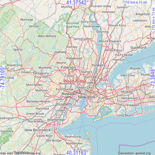
Wood-Ridge GPS coordinates[2]
40° 50' 44.376" North, 74° 5' 16.512" West
| Map corner | latitude | longitude |
|---|---|---|
| Upper-left | 41.37542°, | -74.79105° |
| Center: | 40.84566°, | -74.08792° |
| Lower-right: | 40.31163°, | -73.3848° |
| Map W x H: | 118.3×118.3 km | = 73.5×73.5mi |
| max Lat: | 71.29058° ⇑36.1% North |
| Wood-Ridge: | 40.84566° |
| min Lat: | ⇓63.9% South 19.06759° |
| min Long | Wood-Ridge | max Long |
| -171.73463° | -74.08792° | -66.98998° |
| W 90%⇐ | ⇒10% E |
Elevation
Elevation of Wood-Ridge is 54 m = 177 ft, and this is 240.8 m = 790 ft below average elevation for this country.
| Max E: |
3189 m = 10463 ft | 78.4% |
| Avg. | 294.8 m = 967 ft | |
| Wood-Ridge | 54 m = 177 ft | |
Min E: |
-60 m = -197 ft | 21.6% |
See also: United States elevation on elevation.city.
Geographical zone
Wood-Ridge is located in North temperate zone (between Tropic of Cancer and the Arctic Circle). Distance of this Northern Tropic circle is 1935.7 km =1202.8 mi to South.| Distance of | km | miles | from Wood-Ridge |
|---|---|---|---|
| North Pole | 5465.5 | 3396.1 | to North |
| Arctic Circle | 2859.6 | 1776.9 | to North |
| Tropic Cancer | 1935.7 | 1202.8 | to South |
| Equator | 4541.6 | 2822 | to South |


Nearby cities:
15 places around Wood-Ridge: (largest is in red/bold)
• Bogota
5.9 km =3.7 mi,  55°
55°
• Carlstadt
0.6 km =0.4 mi,  201°
201°
• East Rutherford
1.5 km =0.9 mi,  210°
210°
• Garfield
4.5 km =2.8 mi,  331°
331°
• Hackensack
5.8 km =3.6 mi,  39°
39°
• Hasbrouck Heights
1.5 km =0.9 mi,  23°
23°
• Little Ferry
3.9 km =2.4 mi,  78°
78°
• Lodi
4.1 km =2.5 mi,  5°
5°
• Lyndhurst
4.8 km =3 mi,  219°
219°
• Moonachie
3.6 km =2.2 mi,  97°
97°
• Passaic
3.6 km =2.2 mi,  289°
289°
• Ridgefield Park
5.7 km =3.5 mi, 77°
• Rutherford
2.7 km =1.7 mi, 216°
• Saddle Brook
5.9 km =3.7 mi,  356°
356°
• Wallington
2.3 km =1.4 mi, 290°
Sources, notices
• [Note1] Compared only with cities in United States existing in our database
• [Src1] Map data: © OpenStreetMap contributors (CC-BY-SA)
• [Src2] Other city data from geonames.org with taken over terms of usage.
• [Src3] Geographical zone / Annual Mean Temperature by Robert A. Rohde @ Wikipedia
