Amenia geodata
Amenia (New York) is a populated place; located in United States in America/New_York (GMT-4) time zone. With population of 955 people, there are 16605 cities with bigger population in this country. Compared to other cities in United States, 74.3% of cities are located further ↓South; 92.7% of cities are located further ←West and 56.2% of cities have higher elevation than Amenia. Note1


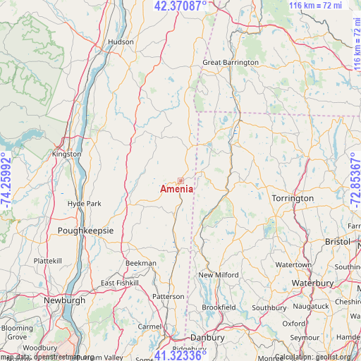
Amenia GPS coordinates[2]
41° 50' 57.336" North, 73° 33' 24.444" West
| Map corner | latitude | longitude |
|---|---|---|
| Upper-left | 42.37087°, | -74.25992° |
| Center: | 41.84926°, | -73.55679° |
| Lower-right: | 41.32336°, | -72.85367° |
| Map W x H: | 116.5×116.5 km | = 72.4×72.4mi |
| max Lat: | 71.29058° ⇑25.7% North |
| Amenia: | 41.84926° |
| min Lat: | ⇓74.3% South 19.06759° |
| min Long | Amenia | max Long |
| -171.73463° | -73.55679° | -66.98998° |
| W 92.7%⇐ | ⇒7.3% E |
Elevation
Elevation of Amenia is 175 m = 574 ft, and this is 119.8 m = 393 ft below average elevation for this country.
| Max E: |
3189 m = 10463 ft | 56.2% |
| Avg. | 294.8 m = 967 ft | |
| Amenia | 175 m = 574 ft | |
Min E: |
-60 m = -197 ft | 43.8% |
See also: United States elevation on elevation.city.
Geographical zone
Amenia is located in North temperate zone (between Tropic of Cancer and the Arctic Circle). Distance of this Northern Tropic circle is 2047.3 km =1272.1 mi to South.| Distance of | km | miles | from Amenia |
|---|---|---|---|
| North Pole | 5353.9 | 3326.8 | to North |
| Arctic Circle | 2748 | 1707.5 | to North |
| Tropic Cancer | 2047.3 | 1272.1 | to South |
| Equator | 4653.2 | 2891.4 | to South |


Nearby cities:
15 places around Amenia: (largest is in red/bold)
• Bantam
30 km =18.6 mi,  117°
117°
• Canaan
27.3 km =17 mi,  43°
43°
• Dover Plains
12.1 km =7.5 mi,  187°
187°
• Falls Village
19.9 km =12.4 mi,  53°
53°
• Haviland
30 km =18.6 mi,  252°
252°
• Kent
15.3 km =9.5 mi,  154°
154°
• Lakeville
16 km =9.9 mi, 36°
• Millbrook
13.4 km =8.3 mi,  237°
237°
• Millerton
12.2 km =7.6 mi,  18°
18°
• New Preston
25.8 km =16 mi,  138°
138°
• Pine Plains
16.7 km =10.4 mi,  330°
330°
• Pleasant Valley
24.8 km =15.4 mi, 242°
• Rhinebeck
30.7 km =19.1 mi,  286°
286°
• Sharon
7.4 km =4.6 mi,  63°
63°
• Sherman
30.4 km =18.9 mi,  170°
170°
Sources, notices
• [Note1] Compared only with cities in United States existing in our database
• [Src1] Map data: © OpenStreetMap contributors (CC-BY-SA)
• [Src2] Other city data from geonames.org with taken over terms of usage.
• [Src3] Geographical zone / Annual Mean Temperature by Robert A. Rohde @ Wikipedia
