Millbrook geodata
Millbrook (New York) is a populated place; located in United States in America/New_York (GMT-4) time zone. With population of 1,425 people, there are 13992 cities with bigger population in this country. Compared to other cities in United States, 73.8% of cities are located further ↓South; 92.1% of cities are located further ←West and 56% of cities have higher elevation than Millbrook. Note1


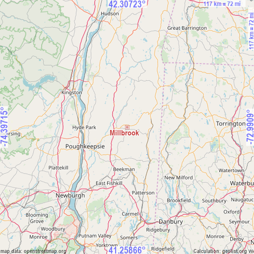
Millbrook GPS coordinates[2]
41° 47' 6.324" North, 73° 41' 38.472" West
| Map corner | latitude | longitude |
|---|---|---|
| Upper-left | 42.30723°, | -74.39715° |
| Center: | 41.78509°, | -73.69402° |
| Lower-right: | 41.25866°, | -72.9909° |
| Map W x H: | 116.6×116.6 km | = 72.5×72.5mi |
| max Lat: | 71.29058° ⇑26.2% North |
| Millbrook: | 41.78509° |
| min Lat: | ⇓73.8% South 19.06759° |
| min Long | Millbrook | max Long |
| -171.73463° | -73.69402° | -66.98998° |
| W 92.1%⇐ | ⇒7.9% E |
Elevation
Elevation of Millbrook is 176 m = 577 ft, and this is 118.8 m = 390 ft below average elevation for this country.
| Max E: |
3189 m = 10463 ft | 56% |
| Avg. | 294.8 m = 967 ft | |
| Millbrook | 176 m = 577 ft | |
Min E: |
-60 m = -197 ft | 44% |
See also: United States elevation on elevation.city.
Geographical zone
Millbrook is located in North temperate zone (between Tropic of Cancer and the Arctic Circle). Distance of this Northern Tropic circle is 2040.1 km =1267.7 mi to South.| Distance of | km | miles | from Millbrook |
|---|---|---|---|
| North Pole | 5361 | 3331.2 | to North |
| Arctic Circle | 2755.1 | 1711.9 | to North |
| Tropic Cancer | 2040.1 | 1267.7 | to South |
| Equator | 4646.1 | 2887 | to South |


Nearby cities:
15 places around Millbrook: (largest is in red/bold)
• Amenia
13.4 km =8.3 mi,  57°
57°
• Arlington
19.5 km =12.1 mi,  239°
239°
• Dover Plains
10.9 km =6.8 mi,  116°
116°
• Fairview
19.9 km =12.4 mi,  249°
249°
• Haviland
17.3 km =10.7 mi,  263°
263°
• Hillside Lake
20.8 km =12.9 mi,  204°
204°
• Hyde Park
19.8 km =12.3 mi,  269°
269°
• Kent
19.2 km =11.9 mi,  110°
110°
• Pine Plains
21.9 km =13.6 mi,  8°
8°
• Pleasant Valley
11.5 km =7.1 mi, 246°
• Poughkeepsie
21.1 km =13.1 mi, 243°
• Red Oaks Mill
20.8 km =12.9 mi,  226°
226°
• Sharon
20.8 km =12.9 mi, 59°
• Spackenkill
23.2 km =14.4 mi, 231°
• Titusville
19.8 km =12.3 mi, 228°
Sources, notices
• [Note1] Compared only with cities in United States existing in our database
• [Src1] Map data: © OpenStreetMap contributors (CC-BY-SA)
• [Src2] Other city data from geonames.org with taken over terms of usage.
• [Src3] Geographical zone / Annual Mean Temperature by Robert A. Rohde @ Wikipedia
