Baldwinsville geodata
Baldwinsville (New York) is a populated place; located in United States in America/New_York (GMT-4) time zone. With population of 7,770 people, there are 5395 cities with bigger population in this country. Compared to other cities in United States, 84.5% of cities are located further ↓South; 83.1% of cities are located further ←West and 67.1% of cities have higher elevation than Baldwinsville. Note1


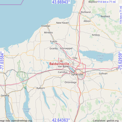
Baldwinsville GPS coordinates[2]
43° 9' 31.248" North, 76° 19' 57.756" West
| Map corner | latitude | longitude |
|---|---|---|
| Upper-left | 43.66943°, | -77.03584° |
| Center: | 43.15868°, | -76.33271° |
| Lower-right: | 42.64363°, | -75.62959° |
| Map W x H: | 114.1×114.1 km | = 70.9×70.9mi |
| max Lat: | 71.29058° ⇑15.5% North |
| Baldwinsville: | 43.15868° |
| min Lat: | ⇓84.5% South 19.06759° |
| min Long | Baldwinsville | max Long |
| -171.73463° | -76.33271° | -66.98998° |
| W 83.1%⇐ | ⇒16.9% E |
Elevation
Elevation of Baldwinsville is 117 m = 384 ft, and this is 177.8 m = 583 ft below average elevation for this country.
| Max E: |
3189 m = 10463 ft | 67.1% |
| Avg. | 294.8 m = 967 ft | |
| Baldwinsville | 117 m = 384 ft | |
Min E: |
-60 m = -197 ft | 32.9% |
See also: United States elevation on elevation.city.
Geographical zone
Baldwinsville is located in North temperate zone (between Tropic of Cancer and the Arctic Circle). Distance of this Northern Tropic circle is 2192.9 km =1362.6 mi to South.| Distance of | km | miles | from Baldwinsville |
|---|---|---|---|
| North Pole | 5208.3 | 3236.3 | to North |
| Arctic Circle | 2602.4 | 1617.1 | to North |
| Tropic Cancer | 2192.9 | 1362.6 | to South |
| Equator | 4798.8 | 2981.8 | to South |


Nearby cities:
15 places around Baldwinsville: (largest is in red/bold)
• Camillus
13.5 km =8.4 mi,  170°
170°
• Fairmount
14.6 km =9.1 mi,  148°
148°
• Galeville
15 km =9.3 mi,  120°
120°
• Jordan
15.4 km =9.6 mi,  227°
227°
• Lakeland
10.7 km =6.6 mi,  135°
135°
• Liverpool
11 km =6.8 mi, 121°
• Mattydale
16.7 km =10.4 mi,  113°
113°
• North Syracuse
16.7 km =10.4 mi,  99°
99°
• Peru
10.5 km =6.5 mi,  215°
215°
• Phoenix
8.5 km =5.3 mi,  17°
17°
• Sand Ridge
13.6 km =8.5 mi,  37°
37°
• Seneca Knolls
5.7 km =3.5 mi, 138°
• Solvay
15.1 km =9.4 mi, 137°
• Village Green
3.2 km =2 mi, 150°
• Westvale
15.4 km =9.6 mi, 143°
Sources, notices
• [Note1] Compared only with cities in United States existing in our database
• [Src1] Map data: © OpenStreetMap contributors (CC-BY-SA)
• [Src2] Other city data from geonames.org with taken over terms of usage.
• [Src3] Geographical zone / Annual Mean Temperature by Robert A. Rohde @ Wikipedia
