Seneca Knolls geodata
Seneca Knolls (New York) is a populated place; located in United States in America/New_York (GMT-4) time zone. With population of 2,011 people, there are 11913 cities with bigger population in this country. Compared to other cities in United States, 84.3% of cities are located further ↓South; 83.2% of cities are located further ←West and 65.2% of cities have higher elevation than Seneca Knolls. Note1


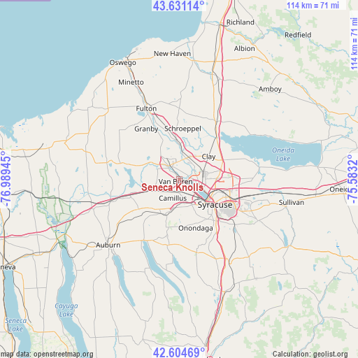
Seneca Knolls GPS coordinates[2]
43° 7' 12.252" North, 76° 17' 10.752" West
| Map corner | latitude | longitude |
|---|---|---|
| Upper-left | 43.63114°, | -76.98945° |
| Center: | 43.12007°, | -76.28632° |
| Lower-right: | 42.60469°, | -75.5832° |
| Map W x H: | 114.1×114.1 km | = 70.9×70.9mi |
| max Lat: | 71.29058° ⇑15.7% North |
| Seneca Knolls: | 43.12007° |
| min Lat: | ⇓84.3% South 19.06759° |
| min Long | Seneca Knolls | max Long |
| -171.73463° | -76.28632° | -66.98998° |
| W 83.2%⇐ | ⇒16.8% E |
Elevation
Elevation of Seneca Knolls is 127 m = 417 ft, and this is 167.8 m = 551 ft below average elevation for this country.
| Max E: |
3189 m = 10463 ft | 65.2% |
| Avg. | 294.8 m = 967 ft | |
| Seneca Knolls | 127 m = 417 ft | |
Min E: |
-60 m = -197 ft | 34.8% |
See also: United States elevation on elevation.city.
Geographical zone
Seneca Knolls is located in North temperate zone (between Tropic of Cancer and the Arctic Circle). Distance of this Northern Tropic circle is 2188.6 km =1359.9 mi to South.| Distance of | km | miles | from Seneca Knolls |
|---|---|---|---|
| North Pole | 5212.6 | 3239 | to North |
| Arctic Circle | 2606.7 | 1619.7 | to North |
| Tropic Cancer | 2188.6 | 1359.9 | to South |
| Equator | 4794.5 | 2979.2 | to South |


Nearby cities:
15 places around Seneca Knolls: (largest is in red/bold)
• Baldwinsville
5.7 km =3.5 mi,  318°
318°
• Camillus
9.1 km =5.7 mi,  189°
189°
• Fairmount
9 km =5.6 mi,  154°
154°
• Galeville
9.8 km =6.1 mi,  109°
109°
• Lakeland
5 km =3.1 mi,  131°
131°
• Liverpool
5.8 km =3.6 mi, 105°
• Lyncourt
13.7 km =8.5 mi, 108°
• Mattydale
11.7 km =7.3 mi,  102°
102°
• North Syracuse
12.8 km =8 mi,  82°
82°
• Peru
10.7 km =6.6 mi,  246°
246°
• Phoenix
12.4 km =7.7 mi,  354°
354°
• Solvay
9.4 km =5.8 mi,  137°
137°
• Syracuse
13.8 km =8.6 mi, 125°
• Village Green
2.6 km =1.6 mi,  304°
304°
• Westvale
9.7 km =6 mi, 146°
Sources, notices
• [Note1] Compared only with cities in United States existing in our database
• [Src1] Map data: © OpenStreetMap contributors (CC-BY-SA)
• [Src2] Other city data from geonames.org with taken over terms of usage.
• [Src3] Geographical zone / Annual Mean Temperature by Robert A. Rohde @ Wikipedia
