Bensonhurst geodata
Bensonhurst (New York) is a populated place; located in United States in America/New_York (GMT-4) time zone. With population of 60,000 people, there are 744 cities with bigger population in this country. Compared to other cities in United States, 60.1% of cities are located further ↓South; 90.6% of cities are located further ←West and 95.7% of cities have higher elevation than Bensonhurst. Note1


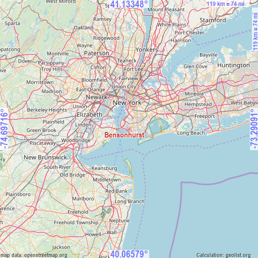
Bensonhurst GPS coordinates[2]
40° 36' 6.372" North, 73° 59' 38.508" West
| Map corner | latitude | longitude |
|---|---|---|
| Upper-left | 41.13348°, | -74.69716° |
| Center: | 40.60177°, | -73.99403° |
| Lower-right: | 40.06579°, | -73.29091° |
| Map W x H: | 118.7×118.7 km | = 73.8×73.8mi |
| max Lat: | 71.29058° ⇑39.9% North |
| Bensonhurst: | 40.60177° |
| min Lat: | ⇓60.1% South 19.06759° |
| min Long | Bensonhurst | max Long |
| -171.73463° | -73.99403° | -66.98998° |
| W 90.6%⇐ | ⇒9.4% E |
Elevation
Elevation of Bensonhurst is 8 m = 26 ft, and this is 286.8 m = 941 ft below average elevation for this country.
| Max E: |
3189 m = 10463 ft | 95.7% |
| Avg. | 294.8 m = 967 ft | |
| Bensonhurst | 8 m = 26 ft | |
Min E: |
-60 m = -197 ft | 4.3% |
See also: Bensonhurst elevation on elevation.city.
Geographical zone
Bensonhurst is located in North temperate zone (between Tropic of Cancer and the Arctic Circle). Distance of this Northern Tropic circle is 1908.6 km =1185.9 mi to South.| Distance of | km | miles | from Bensonhurst |
|---|---|---|---|
| North Pole | 5492.6 | 3412.9 | to North |
| Arctic Circle | 2886.7 | 1793.7 | to North |
| Tropic Cancer | 1908.6 | 1185.9 | to South |
| Equator | 4514.5 | 2805.2 | to South |


Nearby cities:
15 places around Bensonhurst: (largest is in red/bold)
• Bath Beach
0.9 km =0.6 mi,  289°
289°
• Borough Park
3.6 km =2.2 mi,  356°
356°
• Brighton Beach
3.9 km =2.4 mi,  132°
132°
• Brooklyn
6.6 km =4.1 mi,  34°
34°
• Coney Island
2.7 km =1.7 mi,  180°
180°
• Dyker Heights
2.6 km =1.6 mi,  329°
329°
• Flatbush
6.3 km =3.9 mi, 27°
• Flatlands
5.4 km =3.4 mi,  66°
66°
• Fort Hamilton
3.8 km =2.4 mi,  299°
299°
• Fort Wadsworth
5.3 km =3.3 mi,  269°
269°
• Gravesend
2.5 km =1.6 mi,  100°
100°
• Kensington
5.3 km =3.3 mi,  21°
21°
• Rosebank
6.2 km =3.9 mi,  282°
282°
• Sheepshead Bay
4.3 km =2.7 mi,  105°
105°
• Sunset Park
5.1 km =3.2 mi,  342°
342°
Sources, notices
• [Note1] Compared only with cities in United States existing in our database
• [Src1] Map data: © OpenStreetMap contributors (CC-BY-SA)
• [Src2] Other city data from geonames.org with taken over terms of usage.
• [Src3] Geographical zone / Annual Mean Temperature by Robert A. Rohde @ Wikipedia
