Bergen geodata
Bergen (New York) is a populated place; located in United States in America/New_York (GMT-4) time zone. With population of 1,133 people, there are 15480 cities with bigger population in this country. Compared to other cities in United States, 84% of cities are located further ↓South; 77.9% of cities are located further ←West and 53.1% of cities have higher elevation than Bergen. Note1


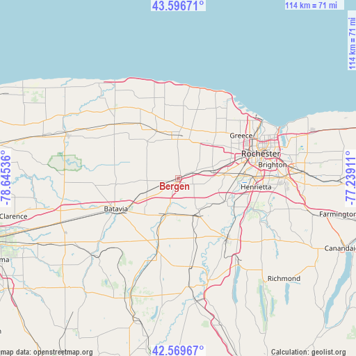
Bergen GPS coordinates[2]
43° 5' 7.224" North, 77° 56' 32.028" West
| Map corner | latitude | longitude |
|---|---|---|
| Upper-left | 43.59671°, | -78.64536° |
| Center: | 43.08534°, | -77.94223° |
| Lower-right: | 42.56967°, | -77.23911° |
| Map W x H: | 114.2×114.2 km | = 71×71mi |
| max Lat: | 71.29058° ⇑16% North |
| Bergen: | 43.08534° |
| min Lat: | ⇓84% South 19.06759° |
| min Long | Bergen | max Long |
| -171.73463° | -77.94223° | -66.98998° |
| W 77.9%⇐ | ⇒22.1% E |
Elevation
Elevation of Bergen is 187 m = 614 ft, and this is 107.8 m = 354 ft below average elevation for this country.
| Max E: |
3189 m = 10463 ft | 53.1% |
| Avg. | 294.8 m = 967 ft | |
| Bergen | 187 m = 614 ft | |
Min E: |
-60 m = -197 ft | 46.9% |
See also: United States elevation on elevation.city.
Geographical zone
Bergen is located in North temperate zone (between Tropic of Cancer and the Arctic Circle). Distance of this Northern Tropic circle is 2184.7 km =1357.5 mi to South.| Distance of | km | miles | from Bergen |
|---|---|---|---|
| North Pole | 5216.4 | 3241.3 | to North |
| Arctic Circle | 2610.5 | 1622.1 | to North |
| Tropic Cancer | 2184.7 | 1357.5 | to South |
| Equator | 4790.6 | 2976.7 | to South |


Nearby cities:
15 places around Bergen: (largest is in red/bold)
• Batavia
22.2 km =13.8 mi,  244°
244°
• Brockport
14.3 km =8.9 mi,  0°
0°
• Caledonia
14.4 km =8.9 mi,  149°
149°
• Churchville
5.1 km =3.2 mi,  65°
65°
• Clarkson
16.5 km =10.3 mi, 4°
• Elba
19.9 km =12.4 mi,  267°
267°
• Gates-North Gates
21.5 km =13.4 mi, 65°
• Hamlin
24.3 km =15.1 mi, 4°
• Holley
17.1 km =10.6 mi,  336°
336°
• Le Roy
12.4 km =7.7 mi,  195°
195°
• North Gates
22 km =13.7 mi,  62°
62°
• Pavilion
24.2 km =15 mi, 195°
• Scottsville
17.3 km =10.7 mi,  112°
112°
• Spencerport
15.9 km =9.9 mi,  44°
44°
• York Hamlet
24.4 km =15.2 mi,  169°
169°
Sources, notices
• [Note1] Compared only with cities in United States existing in our database
• [Src1] Map data: © OpenStreetMap contributors (CC-BY-SA)
• [Src2] Other city data from geonames.org with taken over terms of usage.
• [Src3] Geographical zone / Annual Mean Temperature by Robert A. Rohde @ Wikipedia
