Breesport geodata
Breesport (New York) is a populated place; located in United States in America/New_York (GMT-4) time zone. With population of 626 people, there are 19406 cities with bigger population in this country. Compared to other cities in United States, 77.1% of cities are located further ↓South; 81.7% of cities are located further ←West and 78.4% of cities have lower elevation than Breesport. Note1


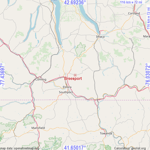
Breesport GPS coordinates[2]
42° 10' 24.276" North, 76° 44' 1.824" West
| Map corner | latitude | longitude |
|---|---|---|
| Upper-left | 42.69236°, | -77.43697° |
| Center: | 42.17341°, | -76.73384° |
| Lower-right: | 41.65017°, | -76.03072° |
| Map W x H: | 115.9×115.9 km | = 72×72mi |
| max Lat: | 71.29058° ⇑22.9% North |
| Breesport: | 42.17341° |
| min Lat: | ⇓77.1% South 19.06759° |
| min Long | Breesport | max Long |
| -171.73463° | -76.73384° | -66.98998° |
| W 81.7%⇐ | ⇒18.3% E |
Elevation
Elevation of Breesport is 339 m = 1112 ft, and this is 44.2 m = 145 ft above average elevation for this country.
| Max E: |
3189 m = 10463 ft | 21.6% |
| Breesport | 339 m 1112 ft | |
| Avg. | 294.8 m = 967 ft | |
Min E: |
-60 m = -197 ft | 78.4% |
See also: United States elevation on elevation.city.
Geographical zone
Breesport is located in North temperate zone (between Tropic of Cancer and the Arctic Circle). Distance of this Northern Tropic circle is 2083.3 km =1294.5 mi to South.| Distance of | km | miles | from Breesport |
|---|---|---|---|
| North Pole | 5317.8 | 3304.3 | to North |
| Arctic Circle | 2711.9 | 1685.1 | to North |
| Tropic Cancer | 2083.3 | 1294.5 | to South |
| Equator | 4689.2 | 2913.7 | to South |


Nearby cities:
15 places around Breesport: (largest is in red/bold)
• Big Flats
17.2 km =10.7 mi,  256°
256°
• Elmira
11.1 km =6.9 mi,  213°
213°
• Elmira Heights
8.7 km =5.4 mi,  235°
235°
• Horseheads
7.2 km =4.5 mi, 264°
• Horseheads North
6.5 km =4 mi,  289°
289°
• Montour Falls
21.4 km =13.3 mi,  334°
334°
• Newfield Hamlet
23.6 km =14.7 mi,  29°
29°
• Odessa
18.7 km =11.6 mi,  346°
346°
• Pine Valley
10.9 km =6.8 mi,  302°
302°
• Southport
14.9 km =9.3 mi, 208°
• Spencer
20.2 km =12.6 mi,  78°
78°
• Van Etten
15.2 km =9.4 mi, 79°
• Waverly
24.9 km =15.5 mi,  136°
136°
• Wellsburg
17.5 km =10.9 mi,  178°
178°
• West Elmira
14 km =8.7 mi,  220°
220°
Sources, notices
• [Note1] Compared only with cities in United States existing in our database
• [Src1] Map data: © OpenStreetMap contributors (CC-BY-SA)
• [Src2] Other city data from geonames.org with taken over terms of usage.
• [Src3] Geographical zone / Annual Mean Temperature by Robert A. Rohde @ Wikipedia
