Pine Valley geodata
Pine Valley (New York) is a populated place; located in United States in America/New_York (GMT-4) time zone. With population of 813 people, there are 17692 cities with bigger population in this country. Compared to other cities in United States, 77.5% of cities are located further ↓South; 81.3% of cities are located further ←West and 70.6% of cities have lower elevation than Pine Valley. Note1


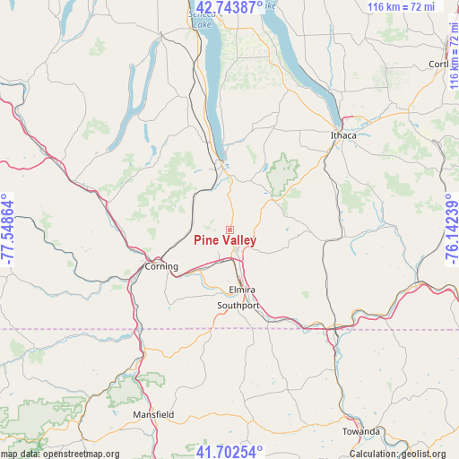
Pine Valley GPS coordinates[2]
42° 13' 31.26" North, 76° 50' 43.836" West
| Map corner | latitude | longitude |
|---|---|---|
| Upper-left | 42.74387°, | -77.54864° |
| Center: | 42.22535°, | -76.84551° |
| Lower-right: | 41.70254°, | -76.14239° |
| Map W x H: | 115.8×115.8 km | = 72×72mi |
| max Lat: | 71.29058° ⇑22.5% North |
| Pine Valley: | 42.22535° |
| min Lat: | ⇓77.5% South 19.06759° |
| min Long | Pine Valley | max Long |
| -171.73463° | -76.84551° | -66.98998° |
| W 81.3%⇐ | ⇒18.7% E |
Elevation
Elevation of Pine Valley is 289 m = 948 ft, and this is 5.8 m = 19 ft below average elevation for this country.
| Max E: |
3189 m = 10463 ft | 29.4% |
| Avg. | 294.8 m = 967 ft | |
| Pine Valley | 289 m = 948 ft | |
Min E: |
-60 m = -197 ft | 70.6% |
See also: United States elevation on elevation.city.
Geographical zone
Pine Valley is located in North temperate zone (between Tropic of Cancer and the Arctic Circle). Distance of this Northern Tropic circle is 2089.1 km =1298.1 mi to South.| Distance of | km | miles | from Pine Valley |
|---|---|---|---|
| North Pole | 5312 | 3300.7 | to North |
| Arctic Circle | 2706.2 | 1681.6 | to North |
| Tropic Cancer | 2089.1 | 1298.1 | to South |
| Equator | 4695 | 2917.3 | to South |


Nearby cities:
15 places around Pine Valley: (largest is in red/bold)
• Big Flats
12.4 km =7.7 mi,  217°
217°
• Breesport
10.9 km =6.8 mi,  122°
122°
• Corning
19.5 km =12.1 mi,  241°
241°
• Elmira
15.4 km =9.6 mi,  168°
168°
• Elmira Heights
10.8 km =6.7 mi, 169°
• Gang Mills
23.6 km =14.7 mi,  248°
248°
• Horseheads
6.8 km =4.2 mi,  162°
162°
• Horseheads North
4.8 km =3 mi,  139°
139°
• Montour Falls
13.6 km =8.5 mi,  0°
0°
• Odessa
13.2 km =8.2 mi,  20°
20°
• Painted Post
21.7 km =13.5 mi, 251°
• South Corning
19.6 km =12.2 mi,  233°
233°
• Southport
19.1 km =11.9 mi, 173°
• Watkins Glen
17.4 km =10.8 mi,  352°
352°
• West Elmira
16.4 km =10.2 mi,  179°
179°
Sources, notices
• [Note1] Compared only with cities in United States existing in our database
• [Src1] Map data: © OpenStreetMap contributors (CC-BY-SA)
• [Src2] Other city data from geonames.org with taken over terms of usage.
• [Src3] Geographical zone / Annual Mean Temperature by Robert A. Rohde @ Wikipedia
