Brinckerhoff geodata
Brinckerhoff (New York) is a populated place; located in United States in America/New_York (GMT-4) time zone. With population of 2,900 people, there are 9800 cities with bigger population in this country. Compared to other cities in United States, 71.3% of cities are located further ↓South; 91.3% of cities are located further ←West and 75.1% of cities have higher elevation than Brinckerhoff. Note1


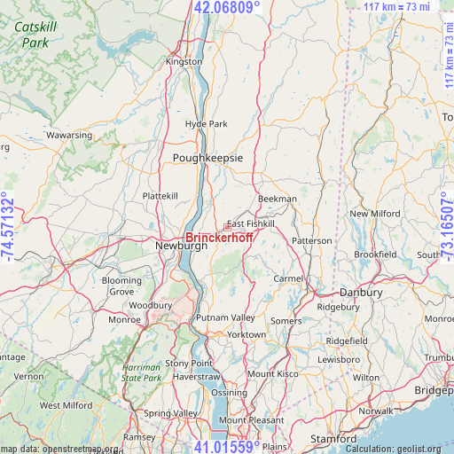
Brinckerhoff GPS coordinates[2]
41° 32' 38.328" North, 73° 52' 5.484" West
| Map corner | latitude | longitude |
|---|---|---|
| Upper-left | 42.06809°, | -74.57132° |
| Center: | 41.54398°, | -73.86819° |
| Lower-right: | 41.01559°, | -73.16507° |
| Map W x H: | 117×117 km | = 72.7×72.7mi |
| max Lat: | 71.29058° ⇑28.7% North |
| Brinckerhoff: | 41.54398° |
| min Lat: | ⇓71.3% South 19.06759° |
| min Long | Brinckerhoff | max Long |
| -171.73463° | -73.86819° | -66.98998° |
| W 91.3%⇐ | ⇒8.7% E |
Elevation
Elevation of Brinckerhoff is 71 m = 233 ft, and this is 223.8 m = 734 ft below average elevation for this country.
| Max E: |
3189 m = 10463 ft | 75.1% |
| Avg. | 294.8 m = 967 ft | |
| Brinckerhoff | 71 m = 233 ft | |
Min E: |
-60 m = -197 ft | 24.9% |
See also: United States elevation on elevation.city.
Geographical zone
Brinckerhoff is located in North temperate zone (between Tropic of Cancer and the Arctic Circle). Distance of this Northern Tropic circle is 2013.3 km =1251 mi to South.| Distance of | km | miles | from Brinckerhoff |
|---|---|---|---|
| North Pole | 5387.8 | 3347.8 | to North |
| Arctic Circle | 2781.9 | 1728.6 | to North |
| Tropic Cancer | 2013.3 | 1251 | to South |
| Equator | 4619.3 | 2870.3 | to South |


Nearby cities:
15 places around Brinckerhoff: (largest is in red/bold)
• Balmville
12.2 km =7.6 mi,  265°
265°
• Beacon
9.5 km =5.9 mi,  242°
242°
• Crown Heights
11.9 km =7.4 mi,  330°
330°
• Fishkill
2.7 km =1.7 mi,  250°
250°
• Hillside Lake
9.8 km =6.1 mi,  36°
36°
• Marlboro
11 km =6.8 mi,  308°
308°
• Merritt Park
0.7 km =0.4 mi,  209°
209°
• Milton
14.9 km =9.3 mi, 330°
• Myers Corner
6.9 km =4.3 mi,  356°
356°
• Nelsonville
14.8 km =9.2 mi, 206°
• Newburgh
12.7 km =7.9 mi, 249°
• Red Oaks Mill
12.4 km =7.7 mi, 357°
• Spackenkill
13 km =8.1 mi,  343°
343°
• Titusville
13.8 km =8.6 mi, 357°
• Wappingers Falls
6.8 km =4.2 mi, 328°
Sources, notices
• [Note1] Compared only with cities in United States existing in our database
• [Src1] Map data: © OpenStreetMap contributors (CC-BY-SA)
• [Src2] Other city data from geonames.org with taken over terms of usage.
• [Src3] Geographical zone / Annual Mean Temperature by Robert A. Rohde @ Wikipedia
