Crown Heights geodata
Crown Heights (New York) is a populated place; located in United States in America/New_York (GMT-4) time zone. With population of 2,840 people, there are 9924 cities with bigger population in this country. Compared to other cities in United States, 72.2% of cities are located further ↓South; 91% of cities are located further ←West and 81.1% of cities have higher elevation than Crown Heights. Note1
Administrative division(s):
- Level 1: New York
- Level 2: Dutchess County
- Level 3: Town of Poughkeepsie


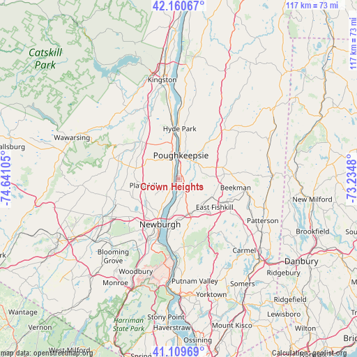
Crown Heights GPS coordinates[2]
41° 38' 14.352" North, 73° 56' 16.512" West
| Map corner | latitude | longitude |
|---|---|---|
| Upper-left | 42.16067°, | -74.64105° |
| Center: | 41.63732°, | -73.93792° |
| Lower-right: | 41.10969°, | -73.2348° |
| Map W x H: | 116.9×116.9 km | = 72.6×72.6mi |
| max Lat: | 71.29058° ⇑27.8% North |
| Crown Heights: | 41.63732° |
| min Lat: | ⇓72.2% South 19.06759° |
| min Long | Crown Heights | max Long |
| -171.73463° | -73.93792° | -66.98998° |
| W 91%⇐ | ⇒9% E |
Elevation
Elevation of Crown Heights is 42 m = 138 ft, and this is 252.8 m = 829 ft below average elevation for this country.
| Max E: |
3189 m = 10463 ft | 81.1% |
| Avg. | 294.8 m = 967 ft | |
| Crown Heights | 42 m = 138 ft | |
Min E: |
-60 m = -197 ft | 18.9% |
See also: United States elevation on elevation.city.
Geographical zone
Crown Heights is located in North temperate zone (between Tropic of Cancer and the Arctic Circle). Distance of this Northern Tropic circle is 2023.7 km =1257.5 mi to South.| Distance of | km | miles | from Crown Heights |
|---|---|---|---|
| North Pole | 5377.4 | 3341.4 | to North |
| Arctic Circle | 2771.5 | 1722.1 | to North |
| Tropic Cancer | 2023.7 | 1257.5 | to South |
| Equator | 4629.6 | 2876.7 | to South |


Nearby cities:
15 places around Crown Heights: (largest is in red/bold)
• Arlington
7.4 km =4.6 mi,  27°
27°
• Clintondale
11.4 km =7.1 mi,  304°
304°
• Fairview
9.7 km =6 mi,  8°
8°
• Fishkill
11.8 km =7.3 mi,  164°
164°
• Highland
9.5 km =5.9 mi,  348°
348°
• Hillside Lake
11.9 km =7.4 mi,  102°
102°
• Marlboro
4.5 km =2.8 mi,  218°
218°
• Milton
3 km =1.9 mi,  327°
327°
• Myers Corner
6.4 km =4 mi,  122°
122°
• Plattekill
11.7 km =7.3 mi,  259°
259°
• Poughkeepsie
7.2 km =4.5 mi, 11°
• Red Oaks Mill
5.6 km =3.5 mi,  68°
68°
• Spackenkill
2.9 km =1.8 mi,  44°
44°
• Titusville
6.3 km =3.9 mi,  57°
57°
• Wappingers Falls
5.1 km =3.2 mi,  153°
153°
Sources, notices
• [Note1] Compared only with cities in United States existing in our database
• [Src1] Map data: © OpenStreetMap contributors (CC-BY-SA)
• [Src2] Other city data from geonames.org with taken over terms of usage.
• [Src3] Geographical zone / Annual Mean Temperature by Robert A. Rohde @ Wikipedia
