Clifton Springs geodata
Clifton Springs (New York) is a populated place; located in United States in America/New_York (GMT-4) time zone. With population of 2,092 people, there are 11650 cities with bigger population in this country. Compared to other cities in United States, 83% of cities are located further ↓South; 80% of cities are located further ←West and 55.1% of cities have higher elevation than Clifton Springs. Note1


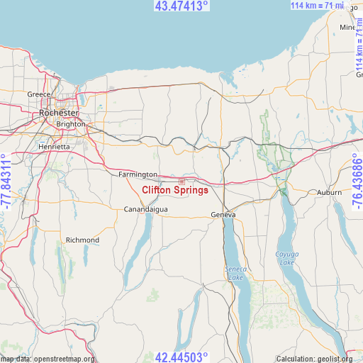
Clifton Springs GPS coordinates[2]
42° 57' 42.228" North, 77° 8' 23.928" West
| Map corner | latitude | longitude |
|---|---|---|
| Upper-left | 43.47413°, | -77.84311° |
| Center: | 42.96173°, | -77.13998° |
| Lower-right: | 42.44503°, | -76.43686° |
| Map W x H: | 114.4×114.4 km | = 71.1×71.1mi |
| max Lat: | 71.29058° ⇑17% North |
| Clifton Springs: | 42.96173° |
| min Lat: | ⇓83% South 19.06759° |
| min Long | Clifton Springs | max Long |
| -171.73463° | -77.13998° | -66.98998° |
| W 80%⇐ | ⇒20% E |
Elevation
Elevation of Clifton Springs is 180 m = 591 ft, and this is 114.8 m = 377 ft below average elevation for this country.
| Max E: |
3189 m = 10463 ft | 55.1% |
| Avg. | 294.8 m = 967 ft | |
| Clifton Springs | 180 m = 591 ft | |
Min E: |
-60 m = -197 ft | 44.9% |
See also: United States elevation on elevation.city.
Geographical zone
Clifton Springs is located in North temperate zone (between Tropic of Cancer and the Arctic Circle). Distance of this Northern Tropic circle is 2171 km =1349 mi to South.| Distance of | km | miles | from Clifton Springs |
|---|---|---|---|
| North Pole | 5230.2 | 3249.9 | to North |
| Arctic Circle | 2624.3 | 1630.7 | to North |
| Tropic Cancer | 2171 | 1349 | to South |
| Equator | 4776.9 | 2968.2 | to South |


Nearby cities:
15 places around Clifton Springs: (largest is in red/bold)
• Canandaigua
15.5 km =9.6 mi,  231°
231°
• Crystal Beach
19.3 km =12 mi,  211°
211°
• Geneva
16.8 km =10.4 mi,  127°
127°
• Gorham
18.1 km =11.2 mi,  177°
177°
• Lyons
16.7 km =10.4 mi,  46°
46°
• Macedon
17.6 km =10.9 mi,  312°
312°
• Manchester
7.4 km =4.6 mi,  276°
276°
• Marion
20.6 km =12.8 mi,  348°
348°
• Newark
10.1 km =6.3 mi,  21°
21°
• Palmyra
13.7 km =8.5 mi,  326°
326°
• Phelps
6.7 km =4.2 mi,  93°
93°
• Rushville
23.5 km =14.6 mi,  197°
197°
• Shortsville
6.6 km =4.1 mi,  264°
264°
• Victor
22 km =13.7 mi, 276°
• Waterloo
23.4 km =14.5 mi,  105°
105°
Sources, notices
• [Note1] Compared only with cities in United States existing in our database
• [Src1] Map data: © OpenStreetMap contributors (CC-BY-SA)
• [Src2] Other city data from geonames.org with taken over terms of usage.
• [Src3] Geographical zone / Annual Mean Temperature by Robert A. Rohde @ Wikipedia
