Rushville geodata
Rushville (New York) is a populated place; located in United States in America/New_York (GMT-4) time zone. With population of 665 people, there are 19022 cities with bigger population in this country. Compared to other cities in United States, 81.6% of cities are located further ↓South; 79.7% of cities are located further ←West and 66.7% of cities have lower elevation than Rushville. Note1


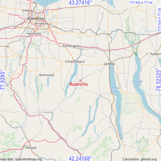
Rushville GPS coordinates[2]
42° 45' 36.252" North, 77° 13' 34.932" West
| Map corner | latitude | longitude |
|---|---|---|
| Upper-left | 43.27416°, | -77.9295° |
| Center: | 42.76007°, | -77.22637° |
| Lower-right: | 42.24168°, | -76.52325° |
| Map W x H: | 114.8×114.8 km | = 71.3×71.3mi |
| max Lat: | 71.29058° ⇑18.4% North |
| Rushville: | 42.76007° |
| min Lat: | ⇓81.6% South 19.06759° |
| min Long | Rushville | max Long |
| -171.73463° | -77.22637° | -66.98998° |
| W 79.7%⇐ | ⇒20.3% E |
Elevation
Elevation of Rushville is 270 m = 886 ft, and this is 24.8 m = 81 ft below average elevation for this country.
| Max E: |
3189 m = 10463 ft | 33.3% |
| Avg. | 294.8 m = 967 ft | |
| Rushville | 270 m = 886 ft | |
Min E: |
-60 m = -197 ft | 66.7% |
See also: United States elevation on elevation.city.
Geographical zone
Rushville is located in North temperate zone (between Tropic of Cancer and the Arctic Circle). Distance of this Northern Tropic circle is 2148.6 km =1335.1 mi to South.| Distance of | km | miles | from Rushville |
|---|---|---|---|
| North Pole | 5252.6 | 3263.8 | to North |
| Arctic Circle | 2646.7 | 1644.6 | to North |
| Tropic Cancer | 2148.6 | 1335.1 | to South |
| Equator | 4754.5 | 2954.3 | to South |


Nearby cities:
15 places around Rushville: (largest is in red/bold)
• Canandaigua
13.7 km =8.5 mi,  338°
338°
• Clifton Springs
23.5 km =14.6 mi,  17°
17°
• Crystal Beach
6.7 km =4.2 mi,  333°
333°
• Geneva
23.6 km =14.7 mi,  59°
59°
• Gorham
8.9 km =5.5 mi, 60°
• Holcomb
22.3 km =13.9 mi,  315°
315°
• Honeoye
23.9 km =14.9 mi,  278°
278°
• Keuka Park
19.5 km =12.1 mi,  145°
145°
• Manchester
23.3 km =14.5 mi,  359°
359°
• Naples
21.6 km =13.4 mi,  221°
221°
• Penn Yan
17.9 km =11.1 mi,  128°
128°
• Phelps
25.9 km =16.1 mi,  32°
32°
• Prattsburgh
26.7 km =16.6 mi,  191°
191°
• Shortsville
21.8 km =13.5 mi,  1°
1°
• Victor
28.9 km =18 mi, 328°
Sources, notices
• [Note1] Compared only with cities in United States existing in our database
• [Src1] Map data: © OpenStreetMap contributors (CC-BY-SA)
• [Src2] Other city data from geonames.org with taken over terms of usage.
• [Src3] Geographical zone / Annual Mean Temperature by Robert A. Rohde @ Wikipedia
