Cuba geodata
Cuba (New York) is a populated place; located in United States in America/New_York (GMT-4) time zone. With population of 1,529 people, there are 13551 cities with bigger population in this country. Compared to other cities in United States, 77.5% of cities are located further ↓South; 77.3% of cities are located further ←West and 86.7% of cities have lower elevation than Cuba. Note1


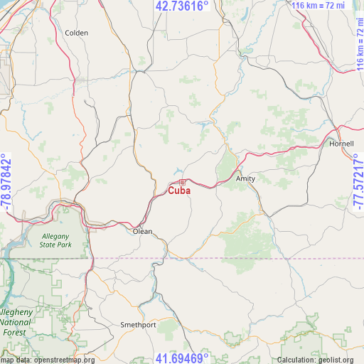
Cuba GPS coordinates[2]
42° 13' 3.252" North, 78° 16' 31.044" West
| Map corner | latitude | longitude |
|---|---|---|
| Upper-left | 42.73616°, | -78.97842° |
| Center: | 42.21757°, | -78.27529° |
| Lower-right: | 41.69469°, | -77.57217° |
| Map W x H: | 115.8×115.8 km | = 72×72mi |
| max Lat: | 71.29058° ⇑22.5% North |
| Cuba: | 42.21757° |
| min Lat: | ⇓77.5% South 19.06759° |
| min Long | Cuba | max Long |
| -171.73463° | -78.27529° | -66.98998° |
| W 77.3%⇐ | ⇒22.7% E |
Elevation
Elevation of Cuba is 458 m = 1503 ft, and this is 163.2 m = 535 ft above average elevation for this country.
| Max E: |
3189 m = 10463 ft | 13.3% |
| Cuba | 458 m 1503 ft | |
| Avg. | 294.8 m = 967 ft | |
Min E: |
-60 m = -197 ft | 86.7% |
See also: United States elevation on elevation.city.
Geographical zone
Cuba is located in North temperate zone (between Tropic of Cancer and the Arctic Circle). Distance of this Northern Tropic circle is 2088.2 km =1297.5 mi to South.| Distance of | km | miles | from Cuba |
|---|---|---|---|
| North Pole | 5312.9 | 3301.3 | to North |
| Arctic Circle | 2707 | 1682.1 | to North |
| Tropic Cancer | 2088.2 | 1297.5 | to South |
| Equator | 4694.2 | 2916.8 | to South |


Nearby cities:
15 places around Cuba: (largest is in red/bold)
• Allegany
22.9 km =14.2 mi,  231°
231°
• Angelica
23.5 km =14.6 mi,  65°
65°
• Belfast
19.4 km =12.1 mi,  44°
44°
• Belmont
19.8 km =12.3 mi,  88°
88°
• Bolivar
19 km =11.8 mi,  152°
152°
• Franklinville
20.1 km =12.5 mi,  311°
311°
• Friendship
11.4 km =7.1 mi,  96°
96°
• Houghton
24.9 km =15.5 mi,  22°
22°
• Lyndon
11.7 km =7.3 mi,  326°
326°
• Olean
20.1 km =12.5 mi,  219°
219°
• Portville
20.6 km =12.8 mi,  195°
195°
• Saint Bonaventure
22.4 km =13.9 mi, 227°
• Scio
25 km =15.5 mi, 101°
• Weston Mills
17.7 km =11 mi,  206°
206°
• Westons Mills
19.2 km =11.9 mi, 205°
Sources, notices
• [Note1] Compared only with cities in United States existing in our database
• [Src1] Map data: © OpenStreetMap contributors (CC-BY-SA)
• [Src2] Other city data from geonames.org with taken over terms of usage.
• [Src3] Geographical zone / Annual Mean Temperature by Robert A. Rohde @ Wikipedia
