Depauville geodata
Depauville (New York) is a populated place; located in United States in America/New_York (GMT-4) time zone. With population of 577 people, there are 19951 cities with bigger population in this country. Compared to other cities in United States, 89% of cities are located further ↓South; 83.8% of cities are located further ←West and 71.7% of cities have higher elevation than Depauville. Note1


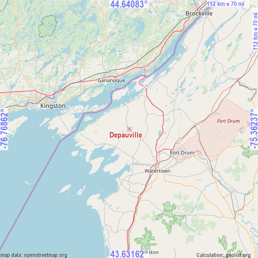
Depauville GPS coordinates[2]
44° 8' 18.168" North, 76° 3' 55.764" West
| Map corner | latitude | longitude |
|---|---|---|
| Upper-left | 44.64083°, | -76.76862° |
| Center: | 44.13838°, | -76.06549° |
| Lower-right: | 43.63162°, | -75.36237° |
| Map W x H: | 112.2×112.2 km | = 69.7×69.7mi |
| max Lat: | 71.29058° ⇑11% North |
| Depauville: | 44.13838° |
| min Lat: | ⇓89% South 19.06759° |
| min Long | Depauville | max Long |
| -171.73463° | -76.06549° | -66.98998° |
| W 83.8%⇐ | ⇒16.2% E |
Elevation
Elevation of Depauville is 91 m = 299 ft, and this is 203.8 m = 669 ft below average elevation for this country.
| Max E: |
3189 m = 10463 ft | 71.7% |
| Avg. | 294.8 m = 967 ft | |
| Depauville | 91 m = 299 ft | |
Min E: |
-60 m = -197 ft | 28.3% |
See also: United States elevation on elevation.city.
Geographical zone
Depauville is located in North temperate zone (between Tropic of Cancer and the Arctic Circle). Distance of this Northern Tropic circle is 2301.8 km =1430.3 mi to South.| Distance of | km | miles | from Depauville |
|---|---|---|---|
| North Pole | 5099.3 | 3168.6 | to North |
| Arctic Circle | 2493.4 | 1549.3 | to North |
| Tropic Cancer | 2301.8 | 1430.3 | to South |
| Equator | 4907.7 | 3049.5 | to South |


Nearby cities:
15 places around Depauville: (largest is in red/bold)
• Alexandria Bay
24.9 km =15.5 mi,  28°
28°
• Black River
25.8 km =16 mi,  122°
122°
• Brownville
16 km =9.9 mi,  156°
156°
• Calcium
21.8 km =13.5 mi,  126°
126°
• Cape Vincent
21.4 km =13.3 mi,  266°
266°
• Chaumont
9.5 km =5.9 mi,  213°
213°
• Clayton
11.4 km =7.1 mi,  351°
351°
• Dexter
14.6 km =9.1 mi,  173°
173°
• Evans Mills
21.4 km =13.3 mi,  105°
105°
• Fort Drum
25.8 km =16 mi, 110°
• Glen Park
17.2 km =10.7 mi,  152°
152°
• La Fargeville
10.1 km =6.3 mi,  51°
51°
• Sackets Harbor
21.8 km =13.5 mi,  191°
191°
• Theresa
23 km =14.3 mi,  68°
68°
• Watertown
22 km =13.7 mi, 145°
Sources, notices
• [Note1] Compared only with cities in United States existing in our database
• [Src1] Map data: © OpenStreetMap contributors (CC-BY-SA)
• [Src2] Other city data from geonames.org with taken over terms of usage.
• [Src3] Geographical zone / Annual Mean Temperature by Robert A. Rohde @ Wikipedia
