Freeport geodata
Freeport (New York) is a populated place; located in United States in America/New_York (GMT-4) time zone. With population of 43,334 people, there are 1101 cities with bigger population in this country. Compared to other cities in United States, 60.9% of cities are located further ↓South; 92.6% of cities are located further ←West and 93.9% of cities have higher elevation than Freeport. Note1


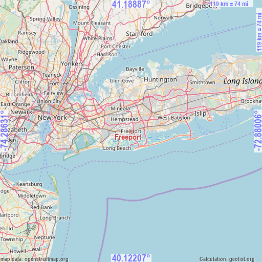
Freeport GPS coordinates[2]
40° 39' 27.36" North, 73° 34' 59.448" West
| Map corner | latitude | longitude |
|---|---|---|
| Upper-left | 41.18887°, | -74.28631° |
| Center: | 40.6576°, | -73.58318° |
| Lower-right: | 40.12207°, | -72.88006° |
| Map W x H: | 118.6×118.6 km | = 73.7×73.7mi |
| max Lat: | 71.29058° ⇑39.1% North |
| Freeport: | 40.6576° |
| min Lat: | ⇓60.9% South 19.06759° |
| min Long | Freeport | max Long |
| -171.73463° | -73.58318° | -66.98998° |
| W 92.6%⇐ | ⇒7.4% E |
Elevation
Elevation of Freeport is 10 m = 33 ft, and this is 284.8 m = 934 ft below average elevation for this country.
| Max E: |
3189 m = 10463 ft | 93.9% |
| Avg. | 294.8 m = 967 ft | |
| Freeport | 10 m = 33 ft | |
Min E: |
-60 m = -197 ft | 6.1% |
See also: Freeport elevation on elevation.city.
Geographical zone
Freeport is located in North temperate zone (between Tropic of Cancer and the Arctic Circle). Distance of this Northern Tropic circle is 1914.8 km =1189.8 mi to South.| Distance of | km | miles | from Freeport |
|---|---|---|---|
| North Pole | 5486.4 | 3409.1 | to North |
| Arctic Circle | 2880.5 | 1789.9 | to North |
| Tropic Cancer | 1914.8 | 1189.8 | to South |
| Equator | 4520.7 | 2809 | to South |


Nearby cities:
15 places around Freeport: (largest is in red/bold)
• Baldwin
2.2 km =1.4 mi,  266°
266°
• Baldwin Harbor
2.9 km =1.8 mi,  226°
226°
• Bellmore
4.9 km =3 mi,  75°
75°
• East Meadow
6.6 km =4.1 mi,  17°
17°
• Hempstead
6.2 km =3.9 mi,  330°
330°
• Lakeview
6.6 km =4.1 mi,  297°
297°
• Merrick
2.7 km =1.7 mi, 77°
• North Bellmore
5.6 km =3.5 mi,  48°
48°
• North Merrick
4.1 km =2.5 mi, 24°
• Oceanside
5.2 km =3.2 mi,  246°
246°
• Rockville Centre
4.9 km =3 mi, 271°
• Roosevelt
2.4 km =1.5 mi,  348°
348°
• South Hempstead
3.8 km =2.4 mi,  313°
313°
• Uniondale
4.8 km =3 mi, 350°
• Wantagh
6.8 km =4.2 mi,  64°
64°
Sources, notices
• [Note1] Compared only with cities in United States existing in our database
• [Src1] Map data: © OpenStreetMap contributors (CC-BY-SA)
• [Src2] Other city data from geonames.org with taken over terms of usage.
• [Src3] Geographical zone / Annual Mean Temperature by Robert A. Rohde @ Wikipedia
