Geneseo geodata
Geneseo (New York) is a seat of a second-order administrative division; located in United States in America/New_York (GMT-4) time zone. With population of 8,173 people, there are 5205 cities with bigger population in this country. Compared to other cities in United States, 81.8% of cities are located further ↓South; 78.2% of cities are located further ←West and 59.6% of cities have lower elevation than Geneseo. Note1


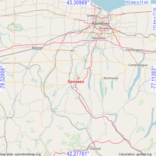
Geneseo GPS coordinates[2]
42° 47' 45.24" North, 77° 49' 1.02" West
| Map corner | latitude | longitude |
|---|---|---|
| Upper-left | 43.30969°, | -78.52008° |
| Center: | 42.7959°, | -77.81695° |
| Lower-right: | 42.27781°, | -77.11383° |
| Map W x H: | 114.7×114.7 km | = 71.3×71.3mi |
| max Lat: | 71.29058° ⇑18.2% North |
| Geneseo: | 42.7959° |
| min Lat: | ⇓81.8% South 19.06759° |
| min Long | Geneseo | max Long |
| -171.73463° | -77.81695° | -66.98998° |
| W 78.2%⇐ | ⇒21.8% E |
Elevation
Elevation of Geneseo is 238 m = 781 ft, and this is 56.8 m = 186 ft below average elevation for this country.
| Max E: |
3189 m = 10463 ft | 40.4% |
| Avg. | 294.8 m = 967 ft | |
| Geneseo | 238 m = 781 ft | |
Min E: |
-60 m = -197 ft | 59.6% |
See also: United States elevation on elevation.city.
Geographical zone
Geneseo is located in North temperate zone (between Tropic of Cancer and the Arctic Circle). Distance of this Northern Tropic circle is 2152.5 km =1337.5 mi to South.| Distance of | km | miles | from Geneseo |
|---|---|---|---|
| North Pole | 5248.6 | 3261.3 | to North |
| Arctic Circle | 2642.7 | 1642.1 | to North |
| Tropic Cancer | 2152.5 | 1337.5 | to South |
| Equator | 4758.5 | 2956.8 | to South |


Nearby cities:
15 places around Geneseo: (largest is in red/bold)
• Avon
14.2 km =8.8 mi,  24°
24°
• Caledonia
19.9 km =12.4 mi,  351°
351°
• East Avon
15.5 km =9.6 mi,  35°
35°
• Hemlock
17.2 km =10.7 mi,  90°
90°
• Honeoye
24.5 km =15.2 mi, 91°
• Honeoye Falls
25.4 km =15.8 mi,  46°
46°
• Lakeville
10.2 km =6.3 mi,  63°
63°
• Le Roy
24.4 km =15.2 mi,  326°
326°
• Lima
20.7 km =12.9 mi, 54°
• Livonia
12.4 km =7.7 mi,  76°
76°
• Mount Morris
9.1 km =5.7 mi,  210°
210°
• Pavilion
19 km =11.8 mi,  298°
298°
• Perry
17.8 km =11.1 mi,  239°
239°
• Springwater Hamlet
25.4 km =15.8 mi,  134°
134°
• York Hamlet
10 km =6.2 mi, 325°
Sources, notices
• [Note1] Compared only with cities in United States existing in our database
• [Src1] Map data: © OpenStreetMap contributors (CC-BY-SA)
• [Src2] Other city data from geonames.org with taken over terms of usage.
• [Src3] Geographical zone / Annual Mean Temperature by Robert A. Rohde @ Wikipedia
