Greenburgh geodata
Greenburgh (New York) is a populated place; located in United States in America/New_York (GMT-4) time zone. With population of 86,764 people, there are 442 cities with bigger population in this country. Compared to other cities in United States, 66.3% of cities are located further ↓South; 91.5% of cities are located further ←West and 76.5% of cities have higher elevation than Greenburgh. Note1


Greenburgh GPS coordinates[2]
41° 1' 58.332" North, 73° 50' 34.476" West
| Map corner | latitude | longitude |
|---|---|---|
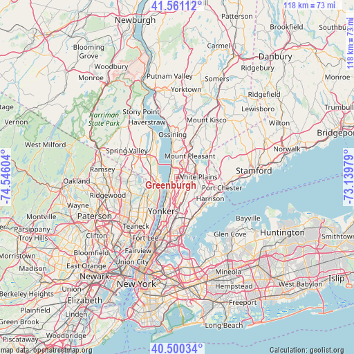
| Upper-left | 41.56112°, | -74.54604° |
| Center: | 41.03287°, | -73.84291° |
| Lower-right: | 40.50034°, | -73.13979° |
| Map W x H: | 117.9×117.9 km | = 73.3×73.3mi |
| max Lat: | 71.29058° ⇑33.7% North |
| Greenburgh: | 41.03287° |
| min Lat: | ⇓66.3% South 19.06759° |
| min Long | Greenburgh | max Long |
| -171.73463° | -73.84291° | -66.98998° |
| W 91.5%⇐ | ⇒8.5% E |
Elevation
Elevation of Greenburgh is 63 m = 207 ft, and this is 231.8 m = 760 ft below average elevation for this country.
| Max E: |
3189 m = 10463 ft | 76.5% |
| Avg. | 294.8 m = 967 ft | |
| Greenburgh | 63 m = 207 ft | |
Min E: |
-60 m = -197 ft | 23.5% |
See also: Greenburgh elevation on elevation.city.
Geographical zone
Greenburgh is located in North temperate zone (between Tropic of Cancer and the Arctic Circle). Distance of this Northern Tropic circle is 1956.5 km =1215.7 mi to South.| Distance of | km | miles | from Greenburgh |
|---|---|---|---|
| North Pole | 5444.6 | 3383.1 | to North |
| Arctic Circle | 2838.7 | 1763.9 | to North |
| Tropic Cancer | 1956.5 | 1215.7 | to South |
| Equator | 4562.4 | 2834.9 | to South |


Nearby cities:
15 places around Greenburgh: (largest is in red/bold)
• Ardsley
2.5 km =1.6 mi,  181°
181°
• Dobbs Ferry
3.2 km =2 mi,  230°
230°
• Elmsford
3.1 km =1.9 mi,  37°
37°
• Fairview
4 km =2.5 mi,  72°
72°
• Greenville
4.8 km =3 mi,  156°
156°
• Hartsdale
4.1 km =2.5 mi,  112°
112°
• Hastings-on-Hudson
5.2 km =3.2 mi,  215°
215°
• Irvington
2.2 km =1.4 mi,  288°
288°
• Piermont
6.4 km =4 mi,  279°
279°
• Scarsdale
5.8 km =3.6 mi,  122°
122°
• Sleepy Hollow
6 km =3.7 mi,  347°
347°
• Sparkill
7.1 km =4.4 mi,  268°
268°
• Tarrytown
5 km =3.1 mi,  344°
344°
• Valhalla
7.4 km =4.6 mi,  50°
50°
• White Plains
6.7 km =4.2 mi,  88°
88°
Sources, notices
• [Note1] Compared only with cities in United States existing in our database
• [Src1] Map data: © OpenStreetMap contributors (CC-BY-SA)
• [Src2] Other city data from geonames.org with taken over terms of usage.
• [Src3] Geographical zone / Annual Mean Temperature by Robert A. Rohde @ Wikipedia
