Hicksville geodata
Hicksville (New York) is a populated place; located in United States in America/New_York (GMT-4) time zone. With population of 41,547 people, there are 1154 cities with bigger population in this country. Compared to other cities in United States, 62.6% of cities are located further ↓South; 92.8% of cities are located further ←West and 79.5% of cities have higher elevation than Hicksville. Note1


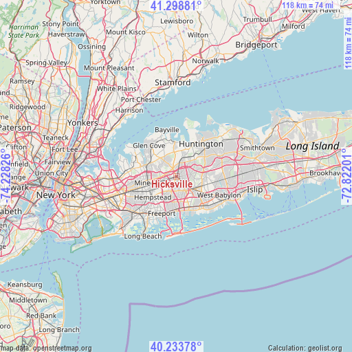
Hicksville GPS coordinates[2]
40° 46' 6.348" North, 73° 31' 30.468" West
| Map corner | latitude | longitude |
|---|---|---|
| Upper-left | 41.29881°, | -74.22826° |
| Center: | 40.76843°, | -73.52513° |
| Lower-right: | 40.23378°, | -72.82201° |
| Map W x H: | 118.4×118.4 km | = 73.6×73.6mi |
| max Lat: | 71.29058° ⇑37.4% North |
| Hicksville: | 40.76843° |
| min Lat: | ⇓62.6% South 19.06759° |
| min Long | Hicksville | max Long |
| -171.73463° | -73.52513° | -66.98998° |
| W 92.8%⇐ | ⇒7.2% E |
Elevation
Elevation of Hicksville is 49 m = 161 ft, and this is 245.8 m = 806 ft below average elevation for this country.
| Max E: |
3189 m = 10463 ft | 79.5% |
| Avg. | 294.8 m = 967 ft | |
| Hicksville | 49 m = 161 ft | |
Min E: |
-60 m = -197 ft | 20.5% |
See also: Hicksville elevation on elevation.city.
Geographical zone
Hicksville is located in North temperate zone (between Tropic of Cancer and the Arctic Circle). Distance of this Northern Tropic circle is 1927.1 km =1197.4 mi to South.| Distance of | km | miles | from Hicksville |
|---|---|---|---|
| North Pole | 5474 | 3401.4 | to North |
| Arctic Circle | 2868.1 | 1782.2 | to North |
| Tropic Cancer | 1927.1 | 1197.4 | to South |
| Equator | 4533 | 2816.7 | to South |


Nearby cities:
15 places around Hicksville: (largest is in red/bold)
• Bethpage
4.5 km =2.8 mi,  126°
126°
• Brookville
6.1 km =3.8 mi,  324°
324°
• East Garden City
7.4 km =4.6 mi,  235°
235°
• East Meadow
6.7 km =4.2 mi,  205°
205°
• Jericho
2.9 km =1.8 mi,  334°
334°
• Levittown
4.8 km =3 mi,  169°
169°
• Muttontown
6.5 km =4 mi,  342°
342°
• New Cassel
3.9 km =2.4 mi,  254°
254°
• Old Bethpage
6.1 km =3.8 mi,  96°
96°
• Old Westbury
6.7 km =4.2 mi,  289°
289°
• Plainedge
6.7 km =4.2 mi,  148°
148°
• Plainview
4.9 km =3 mi,  79°
79°
• Salisbury
3.9 km =2.4 mi,  229°
229°
• Syosset
6.7 km =4.2 mi,  16°
16°
• Westbury
5.5 km =3.4 mi, 254°
Sources, notices
• [Note1] Compared only with cities in United States existing in our database
• [Src1] Map data: © OpenStreetMap contributors (CC-BY-SA)
• [Src2] Other city data from geonames.org with taken over terms of usage.
• [Src3] Geographical zone / Annual Mean Temperature by Robert A. Rohde @ Wikipedia
