Levittown geodata
Levittown (New York) is a populated place; located in United States in America/New_York (GMT-4) time zone. With population of 51,881 people, there are 909 cities with bigger population in this country. Compared to other cities in United States, 62% of cities are located further ↓South; 92.8% of cities are located further ←West and 84.8% of cities have higher elevation than Levittown. Note1


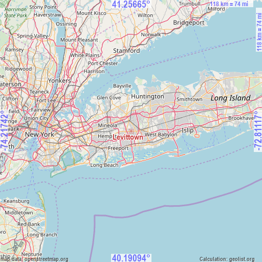
Levittown GPS coordinates[2]
40° 43' 33.348" North, 73° 30' 51.444" West
| Map corner | latitude | longitude |
|---|---|---|
| Upper-left | 41.25665°, | -74.21742° |
| Center: | 40.72593°, | -73.51429° |
| Lower-right: | 40.19094°, | -72.81117° |
| Map W x H: | 118.5×118.5 km | = 73.6×73.6mi |
| max Lat: | 71.29058° ⇑38% North |
| Levittown: | 40.72593° |
| min Lat: | ⇓62% South 19.06759° |
| min Long | Levittown | max Long |
| -171.73463° | -73.51429° | -66.98998° |
| W 92.8%⇐ | ⇒7.2% E |
Elevation
Elevation of Levittown is 29 m = 95 ft, and this is 265.8 m = 872 ft below average elevation for this country.
| Max E: |
3189 m = 10463 ft | 84.8% |
| Avg. | 294.8 m = 967 ft | |
| Levittown | 29 m = 95 ft | |
Min E: |
-60 m = -197 ft | 15.2% |
See also: Levittown elevation on elevation.city.
Geographical zone
Levittown is located in North temperate zone (between Tropic of Cancer and the Arctic Circle). Distance of this Northern Tropic circle is 1922.4 km =1194.5 mi to South.| Distance of | km | miles | from Levittown |
|---|---|---|---|
| North Pole | 5478.8 | 3404.4 | to North |
| Arctic Circle | 2872.9 | 1785.1 | to North |
| Tropic Cancer | 1922.4 | 1194.5 | to South |
| Equator | 4528.3 | 2813.8 | to South |


Nearby cities:
15 places around Levittown: (largest is in red/bold)
• Bellmore
6.5 km =4 mi,  189°
189°
• Bethpage
3.4 km =2.1 mi,  53°
53°
• East Meadow
4 km =2.5 mi,  250°
250°
• Farmingdale
5.9 km =3.7 mi,  82°
82°
• Hicksville
4.8 km =3 mi,  349°
349°
• Massapequa
6.1 km =3.8 mi,  146°
146°
• New Cassel
5.9 km =3.7 mi,  308°
308°
• North Bellmore
4.2 km =2.6 mi,  202°
202°
• North Massapequa
5.2 km =3.2 mi,  122°
122°
• North Merrick
5.6 km =3.5 mi,  226°
226°
• North Wantagh
3.7 km =2.3 mi,  171°
171°
• Plainedge
2.7 km =1.7 mi,  110°
110°
• Salisbury
4.4 km =2.7 mi,  299°
299°
• South Farmingdale
6.3 km =3.9 mi,  95°
95°
• Wantagh
4.7 km =2.9 mi,  175°
175°
Sources, notices
• [Note1] Compared only with cities in United States existing in our database
• [Src1] Map data: © OpenStreetMap contributors (CC-BY-SA)
• [Src2] Other city data from geonames.org with taken over terms of usage.
• [Src3] Geographical zone / Annual Mean Temperature by Robert A. Rohde @ Wikipedia
