Hyde Park geodata
Hyde Park (New York) is a populated place; located in United States in America/New_York (GMT-4) time zone. With population of 1,908 people, there are 12204 cities with bigger population in this country. Compared to other cities in United States, 73.8% of cities are located further ↓South; 91% of cities are located further ←West and 77.7% of cities have higher elevation than Hyde Park. Note1


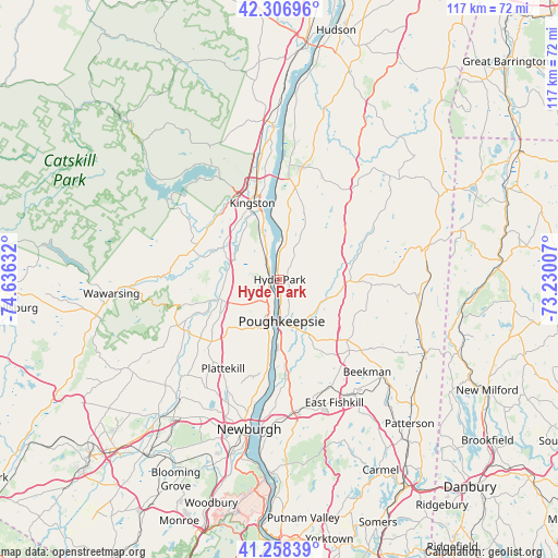
Hyde Park GPS coordinates[2]
41° 47' 5.352" North, 73° 55' 59.484" West
| Map corner | latitude | longitude |
|---|---|---|
| Upper-left | 42.30696°, | -74.63632° |
| Center: | 41.78482°, | -73.93319° |
| Lower-right: | 41.25839°, | -73.23007° |
| Map W x H: | 116.6×116.6 km | = 72.5×72.5mi |
| max Lat: | 71.29058° ⇑26.2% North |
| Hyde Park: | 41.78482° |
| min Lat: | ⇓73.8% South 19.06759° |
| min Long | Hyde Park | max Long |
| -171.73463° | -73.93319° | -66.98998° |
| W 91%⇐ | ⇒9% E |
Elevation
Elevation of Hyde Park is 57 m = 187 ft, and this is 237.8 m = 780 ft below average elevation for this country.
| Max E: |
3189 m = 10463 ft | 77.7% |
| Avg. | 294.8 m = 967 ft | |
| Hyde Park | 57 m = 187 ft | |
Min E: |
-60 m = -197 ft | 22.3% |
See also: United States elevation on elevation.city.
Geographical zone
Hyde Park is located in North temperate zone (between Tropic of Cancer and the Arctic Circle). Distance of this Northern Tropic circle is 2040.1 km =1267.7 mi to South.| Distance of | km | miles | from Hyde Park |
|---|---|---|---|
| North Pole | 5361 | 3331.2 | to North |
| Arctic Circle | 2755.1 | 1711.9 | to North |
| Tropic Cancer | 2040.1 | 1267.7 | to South |
| Equator | 4646 | 2886.9 | to South |


Nearby cities:
15 places around Hyde Park: (largest is in red/bold)
• Arlington
10.3 km =6.4 mi,  163°
163°
• Clintondale
14 km =8.7 mi,  224°
224°
• Fairview
6.9 km =4.3 mi,  170°
170°
• Haviland
3.3 km =2.1 mi,  127°
127°
• Highland
7.4 km =4.6 mi,  197°
197°
• Milton
14 km =8.7 mi,  188°
188°
• New Paltz
13.4 km =8.3 mi,  251°
251°
• Pleasant Valley
10.3 km =6.4 mi,  115°
115°
• Port Ewen
13.9 km =8.6 mi,  345°
345°
• Poughkeepsie
9.4 km =5.8 mi, 173°
• Red Oaks Mill
15.2 km =9.4 mi, 161°
• Rosendale Village
13.7 km =8.5 mi,  302°
302°
• Spackenkill
14.4 km =8.9 mi, 173°
• Tillson
12.2 km =7.6 mi,  293°
293°
• Titusville
13.9 km =8.6 mi, 159°
Sources, notices
• [Note1] Compared only with cities in United States existing in our database
• [Src1] Map data: © OpenStreetMap contributors (CC-BY-SA)
• [Src2] Other city data from geonames.org with taken over terms of usage.
• [Src3] Geographical zone / Annual Mean Temperature by Robert A. Rohde @ Wikipedia
