Kiantone geodata
Kiantone (New York) is a populated place; located in United States in America/New_York (GMT-4) time zone. With population of 1,332 people, there are 14424 cities with bigger population in this country. Compared to other cities in United States, 75.9% of cities are located further ↓South; 75.4% of cities are located further ←West and 86.9% of cities have lower elevation than Kiantone. Note1


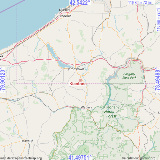
Kiantone GPS coordinates[2]
42° 1' 19.2" North, 79° 11' 53.16" West
| Map corner | latitude | longitude |
|---|---|---|
| Upper-left | 42.5422°, | -79.90123° |
| Center: | 42.022°, | -79.1981° |
| Lower-right: | 41.49751°, | -78.49498° |
| Map W x H: | 116.2×116.2 km | = 72.2×72.2mi |
| max Lat: | 71.29058° ⇑24.1% North |
| Kiantone: | 42.022° |
| min Lat: | ⇓75.9% South 19.06759° |
| min Long | Kiantone | max Long |
| -171.73463° | -79.1981° | -66.98998° |
| W 75.4%⇐ | ⇒24.6% E |
Elevation
Elevation of Kiantone is 465 m = 1526 ft, and this is 170.2 m = 558 ft above average elevation for this country.
| Max E: |
3189 m = 10463 ft | 13.1% |
| Kiantone | 465 m 1526 ft | |
| Avg. | 294.8 m = 967 ft | |
Min E: |
-60 m = -197 ft | 86.9% |
See also: United States elevation on elevation.city.
Geographical zone
Kiantone is located in North temperate zone (between Tropic of Cancer and the Arctic Circle). Distance of this Northern Tropic circle is 2066.5 km =1284.1 mi to South.| Distance of | km | miles | from Kiantone |
|---|---|---|---|
| North Pole | 5334.7 | 3314.8 | to North |
| Arctic Circle | 2728.8 | 1695.6 | to North |
| Tropic Cancer | 2066.5 | 1284.1 | to South |
| Equator | 4672.4 | 2903.3 | to South |


Nearby cities:
15 places around Kiantone: (largest is in red/bold)
• Celoron
12 km =7.5 mi,  324°
324°
• East Randolph
26.6 km =16.5 mi,  50°
50°
• Falconer
10.7 km =6.6 mi,  359°
359°
• Frewsburg
4.9 km =3 mi,  42°
42°
• Jamestown
8.9 km =5.5 mi,  339°
339°
• Jamestown West
10.1 km =6.3 mi, 317°
• Lakewood
14.4 km =8.9 mi,  309°
309°
• North Warren
16.9 km =10.5 mi,  167°
167°
• Randolph
24.1 km =15 mi, 49°
• Russell
10.4 km =6.5 mi,  149°
149°
• Sinclairville
27.4 km =17 mi,  349°
349°
• Starbrick
20.2 km =12.6 mi,  181°
181°
• Sugar Grove
12.4 km =7.7 mi,  249°
249°
• Warren
20.3 km =12.6 mi, 167°
• Youngsville
21.3 km =13.2 mi,  207°
207°
Sources, notices
• [Note1] Compared only with cities in United States existing in our database
• [Src1] Map data: © OpenStreetMap contributors (CC-BY-SA)
• [Src2] Other city data from geonames.org with taken over terms of usage.
• [Src3] Geographical zone / Annual Mean Temperature by Robert A. Rohde @ Wikipedia
