Jamestown geodata
Jamestown (New York) is a populated place; located in United States in America/New_York (GMT-4) time zone. With population of 30,075 people, there are 1660 cities with bigger population in this country. Compared to other cities in United States, 76.5% of cities are located further ↓South; 75.3% of cities are located further ←West and 84.8% of cities have lower elevation than Jamestown. Note1


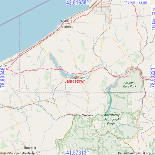
Jamestown GPS coordinates[2]
42° 5' 49.2" North, 79° 14' 7.188" West
| Map corner | latitude | longitude |
|---|---|---|
| Upper-left | 42.61658°, | -79.93846° |
| Center: | 42.097°, | -79.23533° |
| Lower-right: | 41.57313°, | -78.53221° |
| Map W x H: | 116×116 km | = 72.1×72.1mi |
| max Lat: | 71.29058° ⇑23.5% North |
| Jamestown: | 42.097° |
| min Lat: | ⇓76.5% South 19.06759° |
| min Long | Jamestown | max Long |
| -171.73463° | -79.23533° | -66.98998° |
| W 75.3%⇐ | ⇒24.7% E |
Elevation
Elevation of Jamestown is 420 m = 1378 ft, and this is 125.2 m = 411 ft above average elevation for this country.
| Max E: |
3189 m = 10463 ft | 15.2% |
| Jamestown | 420 m 1378 ft | |
| Avg. | 294.8 m = 967 ft | |
Min E: |
-60 m = -197 ft | 84.8% |
See also: United States elevation on elevation.city.
Geographical zone
Jamestown is located in North temperate zone (between Tropic of Cancer and the Arctic Circle). Distance of this Northern Tropic circle is 2074.8 km =1289.2 mi to South.| Distance of | km | miles | from Jamestown |
|---|---|---|---|
| North Pole | 5326.3 | 3309.6 | to North |
| Arctic Circle | 2720.4 | 1690.4 | to North |
| Tropic Cancer | 2074.8 | 1289.2 | to South |
| Equator | 4680.7 | 2908.5 | to South |


Nearby cities:
15 places around Jamestown: (largest is in red/bold)
• Cassadaga
28.2 km =17.5 mi,  347°
347°
• Celoron
4.2 km =2.6 mi,  289°
289°
• East Randolph
25.2 km =15.7 mi,  70°
70°
• Falconer
3.9 km =2.4 mi,  51°
51°
• Frewsburg
7.9 km =4.9 mi,  126°
126°
• Jamestown West
3.9 km =2.4 mi,  255°
255°
• Kiantone
8.9 km =5.5 mi,  159°
159°
• Lakewood
8.1 km =5 mi,  275°
275°
• Mayville
28.2 km =17.5 mi,  308°
308°
• North Warren
25.7 km =16 mi, 164°
• Randolph
22.6 km =14 mi, 71°
• Russell
19.2 km =11.9 mi,  154°
154°
• Sinclairville
18.7 km =11.6 mi, 354°
• Sugar Grove
15.3 km =9.5 mi,  213°
213°
• Youngsville
28.1 km =17.5 mi,  194°
194°
Sources, notices
• [Note1] Compared only with cities in United States existing in our database
• [Src1] Map data: © OpenStreetMap contributors (CC-BY-SA)
• [Src2] Other city data from geonames.org with taken over terms of usage.
• [Src3] Geographical zone / Annual Mean Temperature by Robert A. Rohde @ Wikipedia
