Harlem geodata
Harlem (New York) is a populated place; located in United States in America/New_York (GMT-4) time zone. With population of 181,259 people, there are 147 cities with bigger population in this country. Compared to other cities in United States, 63.3% of cities are located further ↓South; 90.9% of cities are located further ←West and 90.5% of cities have higher elevation than Harlem. Note1


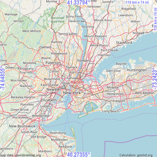
Harlem GPS coordinates[2]
40° 48' 28.368" North, 73° 56' 43.512" West
| Map corner | latitude | longitude |
|---|---|---|
| Upper-left | 41.33794°, | -74.64855° |
| Center: | 40.80788°, | -73.94542° |
| Lower-right: | 40.27355°, | -73.2423° |
| Map W x H: | 118.3×118.3 km | = 73.5×73.5mi |
| max Lat: | 71.29058° ⇑36.7% North |
| Harlem: | 40.80788° |
| min Lat: | ⇓63.3% South 19.06759° |
| min Long | Harlem | max Long |
| -171.73463° | -73.94542° | -66.98998° |
| W 90.9%⇐ | ⇒9.1% E |
Elevation
Elevation of Harlem is 15 m = 49 ft, and this is 279.8 m = 918 ft below average elevation for this country.
| Max E: |
3189 m = 10463 ft | 90.5% |
| Avg. | 294.8 m = 967 ft | |
| Harlem | 15 m = 49 ft | |
Min E: |
-60 m = -197 ft | 9.5% |
See also: Harlem elevation on elevation.city.
Geographical zone
Harlem is located in North temperate zone (between Tropic of Cancer and the Arctic Circle). Distance of this Northern Tropic circle is 1931.5 km =1200.2 mi to South.| Distance of | km | miles | from Harlem |
|---|---|---|---|
| North Pole | 5469.7 | 3398.7 | to North |
| Arctic Circle | 2863.8 | 1779.5 | to North |
| Tropic Cancer | 1931.5 | 1200.2 | to South |
| Equator | 4537.4 | 2819.4 | to South |


Nearby cities:
15 places around Harlem: (largest is in red/bold)
• Astoria
4.2 km =2.6 mi,  162°
162°
• Cliffside Park
3.9 km =2.4 mi,  293°
293°
• East Harlem
1.5 km =0.9 mi,  170°
170°
• Edgewater
3.3 km =2.1 mi,  309°
309°
• Fairview
4.5 km =2.8 mi,  276°
276°
• Hunts Point
5.2 km =3.2 mi,  84°
84°
• Manhattan
3.2 km =2 mi,  212°
212°
• Melrose
3.5 km =2.2 mi,  57°
57°
• Morningside Heights
1.5 km =0.9 mi, 279°
• Morris Heights
5.1 km =3.2 mi,  24°
24°
• Morrisania
4 km =2.5 mi,  53°
53°
• Mott Haven
1.9 km =1.2 mi,  86°
86°
• Port Morris
3.1 km =1.9 mi,  103°
103°
• Steinway
5.1 km =3.2 mi,  136°
136°
• Washington Heights
4.8 km =3 mi,  10°
10°
Sources, notices
• [Note1] Compared only with cities in United States existing in our database
• [Src1] Map data: © OpenStreetMap contributors (CC-BY-SA)
• [Src2] Other city data from geonames.org with taken over terms of usage.
• [Src3] Geographical zone / Annual Mean Temperature by Robert A. Rohde @ Wikipedia
