Penn Yan geodata
Penn Yan (New York) is a seat of a second-order administrative division; located in United States in America/New_York (GMT-4) time zone. With population of 5,014 people, there are 7158 cities with bigger population in this country. Compared to other cities in United States, 81% of cities are located further ↓South; 80.4% of cities are located further ←West and 56.9% of cities have lower elevation than Penn Yan. Note1


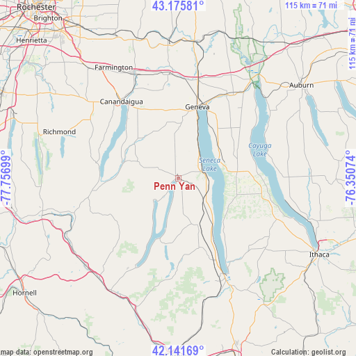
Penn Yan GPS coordinates[2]
42° 39' 39.24" North, 77° 3' 13.896" West
| Map corner | latitude | longitude |
|---|---|---|
| Upper-left | 43.17581°, | -77.75699° |
| Center: | 42.6609°, | -77.05386° |
| Lower-right: | 42.14169°, | -76.35074° |
| Map W x H: | 115×115 km | = 71.5×71.5mi |
| max Lat: | 71.29058° ⇑19% North |
| Penn Yan: | 42.6609° |
| min Lat: | ⇓81% South 19.06759° |
| min Long | Penn Yan | max Long |
| -171.73463° | -77.05386° | -66.98998° |
| W 80.4%⇐ | ⇒19.6% E |
Elevation
Elevation of Penn Yan is 226 m = 741 ft, and this is 68.8 m = 226 ft below average elevation for this country.
| Max E: |
3189 m = 10463 ft | 43.1% |
| Avg. | 294.8 m = 967 ft | |
| Penn Yan | 226 m = 741 ft | |
Min E: |
-60 m = -197 ft | 56.9% |
See also: United States elevation on elevation.city.
Geographical zone
Penn Yan is located in North temperate zone (between Tropic of Cancer and the Arctic Circle). Distance of this Northern Tropic circle is 2137.5 km =1328.2 mi to South.| Distance of | km | miles | from Penn Yan |
|---|---|---|---|
| North Pole | 5263.6 | 3270.6 | to North |
| Arctic Circle | 2657.7 | 1651.4 | to North |
| Tropic Cancer | 2137.5 | 1328.2 | to South |
| Equator | 4743.4 | 2947.4 | to South |


Nearby cities:
15 places around Penn Yan: (largest is in red/bold)
• Aurora
30.5 km =19 mi,  70°
70°
• Canandaigua
30.5 km =19 mi,  321°
321°
• Crystal Beach
24.1 km =15 mi,  314°
314°
• Dundee
16.5 km =10.3 mi,  157°
157°
• Geneva
24 km =14.9 mi,  15°
15°
• Gorham
16.6 km =10.3 mi,  337°
337°
• Hammondsport
31.4 km =19.5 mi,  206°
206°
• Interlaken
27.3 km =17 mi,  100°
100°
• Keuka Park
6 km =3.7 mi, 211°
• Naples
29 km =18 mi,  259°
259°
• Ovid
19 km =11.8 mi,  84°
84°
• Prattsburgh
24.5 km =15.2 mi,  231°
231°
• Rushville
17.9 km =11.1 mi, 308°
• Sylvan Beach
22.3 km =13.9 mi,  191°
191°
• Waterloo
31.3 km =19.4 mi,  29°
29°
Sources, notices
• [Note1] Compared only with cities in United States existing in our database
• [Src1] Map data: © OpenStreetMap contributors (CC-BY-SA)
• [Src2] Other city data from geonames.org with taken over terms of usage.
• [Src3] Geographical zone / Annual Mean Temperature by Robert A. Rohde @ Wikipedia
