Saint James geodata
Saint James (New York) is a populated place; located in United States in America/New_York (GMT-4) time zone. With population of 13,338 people, there are 3586 cities with bigger population in this country. Compared to other cities in United States, 64.4% of cities are located further ↓South; 93.5% of cities are located further ←West and 78.8% of cities have higher elevation than Saint James. Note1


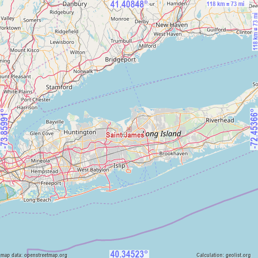
Saint James GPS coordinates[2]
40° 52' 44.364" North, 73° 9' 24.408" West
| Map corner | latitude | longitude |
|---|---|---|
| Upper-left | 41.40848°, | -73.85991° |
| Center: | 40.87899°, | -73.15678° |
| Lower-right: | 40.34523°, | -72.45366° |
| Map W x H: | 118.2×118.2 km | = 73.4×73.4mi |
| max Lat: | 71.29058° ⇑35.6% North |
| Saint James: | 40.87899° |
| min Lat: | ⇓64.4% South 19.06759° |
| min Long | Saint James | max Long |
| -171.73463° | -73.15678° | -66.98998° |
| W 93.5%⇐ | ⇒6.5% E |
Elevation
Elevation of Saint James is 52 m = 171 ft, and this is 242.8 m = 797 ft below average elevation for this country.
| Max E: |
3189 m = 10463 ft | 78.8% |
| Avg. | 294.8 m = 967 ft | |
| Saint James | 52 m = 171 ft | |
Min E: |
-60 m = -197 ft | 21.2% |
See also: United States elevation on elevation.city.
Geographical zone
Saint James is located in North temperate zone (between Tropic of Cancer and the Arctic Circle). Distance of this Northern Tropic circle is 1939.4 km =1205.1 mi to South.| Distance of | km | miles | from Saint James |
|---|---|---|---|
| North Pole | 5461.7 | 3393.7 | to North |
| Arctic Circle | 2855.9 | 1774.6 | to North |
| Tropic Cancer | 1939.4 | 1205.1 | to South |
| Equator | 4545.3 | 2824.3 | to South |


Nearby cities:
15 places around Saint James: (largest is in red/bold)
• Centereach
5.3 km =3.3 mi,  115°
115°
• East Setauket
8.2 km =5.1 mi,  31°
31°
• Hauppauge
7.1 km =4.4 mi,  213°
213°
• Head of the Harbor
2.7 km =1.7 mi,  358°
358°
• Islandia
8.4 km =5.2 mi,  187°
187°
• Lake Grove
4.6 km =2.9 mi,  129°
129°
• Lake Ronkonkoma
5.3 km =3.3 mi,  156°
156°
• Nesconset
3 km =1.9 mi,  175°
175°
• Nissequogue
4.4 km =2.7 mi,  308°
308°
• Ronkonkoma
8 km =5 mi,  152°
152°
• Setauket-East Setauket
7.4 km =4.6 mi,  38°
38°
• Smithtown
4.5 km =2.8 mi,  235°
235°
• Stony Brook
5.4 km =3.4 mi,  14°
14°
• Terryville
8.4 km =5.2 mi,  66°
66°
• Village of the Branch
3.6 km =2.2 mi,  225°
225°
Sources, notices
• [Note1] Compared only with cities in United States existing in our database
• [Src1] Map data: © OpenStreetMap contributors (CC-BY-SA)
• [Src2] Other city data from geonames.org with taken over terms of usage.
• [Src3] Geographical zone / Annual Mean Temperature by Robert A. Rohde @ Wikipedia
