Setauket-East Setauket geodata
Setauket-East Setauket (New York) is a populated place; located in United States in America/New_York (GMT-4) time zone. With population of 15,477 people, there are 3148 cities with bigger population in this country. Compared to other cities in United States, 65.1% of cities are located further ↓South; 93.7% of cities are located further ←West and 83.2% of cities have higher elevation than Setauket-East Setauket. Note1
Current local time in Setauket-East Setauket:
11:17 AM, WednesdayDifference from your time zone: hours


Setauket-East Setauket GPS coordinates[2]
40° 55' 50.304" North, 73° 6' 6.444" West
| Map corner | latitude | longitude |
|---|---|---|
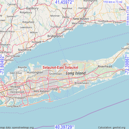
| Upper-left | 41.45972°, | -73.80492° |
| Center: | 40.93064°, | -73.10179° |
| Lower-right: | 40.39729°, | -72.39867° |
| Map W x H: | 118.1×118.1 km | = 73.4×73.4mi |
| max Lat: | 71.29058° ⇑34.9% North |
| Setauket-East Setauket: | 40.93064° |
| min Lat: | ⇓65.1% South 19.06759° |
| min Long | Setauket-East S | max Long |
| -171.73463° | -73.10179° | -66.98998° |
| W 93.7%⇐ | ⇒6.3% E |
Elevation
Elevation of Setauket-East Setauket is 34 m = 112 ft, and this is 260.8 m = 856 ft below average elevation for this country.
| Max E: |
3189 m = 10463 ft | 83.2% |
| Avg. | 294.8 m = 967 ft | |
| Setauket-East Setauket | 34 m = 112 ft | |
Min E: |
-60 m = -197 ft | 16.8% |
See also: United States elevation on elevation.city.
Geographical zone
Setauket-East Setauket is located in North temperate zone (between Tropic of Cancer and the Arctic Circle). Distance of this Northern Tropic circle is 1945.1 km =1208.6 mi to South.| Distance of | km | miles | from Setauket-East Setauket |
|---|---|---|---|
| North Pole | 5456 | 3390.2 | to North |
| Arctic Circle | 2850.1 | 1771 | to North |
| Tropic Cancer | 1945.1 | 1208.6 | to South |
| Equator | 4551.1 | 2827.9 | to South |


Nearby cities:
15 places around Setauket-East Setauket: (largest is in red/bold)
• Belle Terre
4.3 km =2.7 mi,  41°
41°
• Centereach
8 km =5 mi,  178°
178°
• East Setauket
1.3 km =0.8 mi,  343°
343°
• Head of the Harbor
5.6 km =3.5 mi,  237°
237°
• Lake Grove
8.7 km =5.4 mi,  187°
187°
• Mount Sinai
6.3 km =3.9 mi,  73°
73°
• Nissequogue
8.6 km =5.3 mi,  249°
249°
• Old Field
4 km =2.5 mi,  324°
324°
• Poquott
2.7 km =1.7 mi,  33°
33°
• Port Jefferson
3.3 km =2.1 mi,  57°
57°
• Port Jefferson Station
4.6 km =2.9 mi,  97°
97°
• Saint James
7.4 km =4.6 mi,  218°
218°
• Selden
9 km =5.6 mi,  142°
142°
• Stony Brook
3.3 km =2.1 mi,  260°
260°
• Terryville
3.9 km =2.4 mi,  127°
127°
Sources, notices
• [Note1] Compared only with cities in United States existing in our database
• [Src1] Map data: © OpenStreetMap contributors (CC-BY-SA)
• [Src2] Other city data from geonames.org with taken over terms of usage.
• [Src3] Geographical zone / Annual Mean Temperature by Robert A. Rohde @ Wikipedia
