Saugerties geodata
Saugerties (New York) is a populated place; located in United States in America/New_York (GMT-4) time zone. With population of 3,903 people, there are 8324 cities with bigger population in this country. Compared to other cities in United States, 76.3% of cities are located further ↓South; 90.9% of cities are located further ←West and 79.7% of cities have higher elevation than Saugerties. Note1


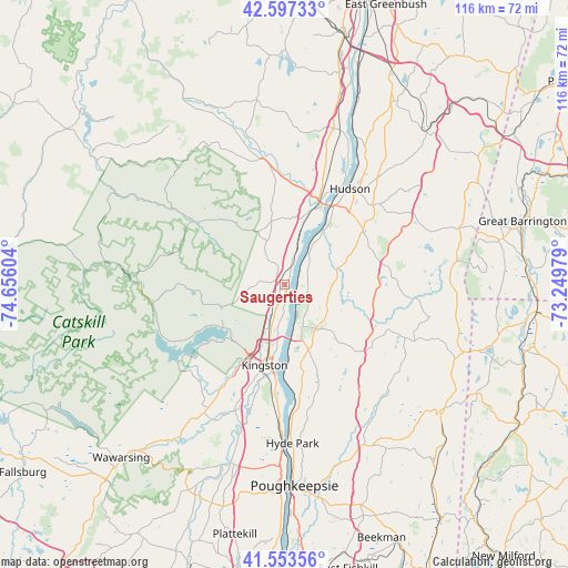
Saugerties GPS coordinates[2]
42° 4' 39.324" North, 73° 57' 10.476" West
| Map corner | latitude | longitude |
|---|---|---|
| Upper-left | 42.59733°, | -74.65604° |
| Center: | 42.07759°, | -73.95291° |
| Lower-right: | 41.55356°, | -73.24979° |
| Map W x H: | 116.1×116.1 km | = 72.1×72.1mi |
| max Lat: | 71.29058° ⇑23.7% North |
| Saugerties: | 42.07759° |
| min Lat: | ⇓76.3% South 19.06759° |
| min Long | Saugerties | max Long |
| -171.73463° | -73.95291° | -66.98998° |
| W 90.9%⇐ | ⇒9.1% E |
Elevation
Elevation of Saugerties is 48 m = 157 ft, and this is 246.8 m = 810 ft below average elevation for this country.
| Max E: |
3189 m = 10463 ft | 79.7% |
| Avg. | 294.8 m = 967 ft | |
| Saugerties | 48 m = 157 ft | |
Min E: |
-60 m = -197 ft | 20.3% |
See also: United States elevation on elevation.city.
Geographical zone
Saugerties is located in North temperate zone (between Tropic of Cancer and the Arctic Circle). Distance of this Northern Tropic circle is 2072.7 km =1287.9 mi to South.| Distance of | km | miles | from Saugerties |
|---|---|---|---|
| North Pole | 5328.5 | 3311 | to North |
| Arctic Circle | 2722.6 | 1691.7 | to North |
| Tropic Cancer | 2072.7 | 1287.9 | to South |
| Equator | 4678.6 | 2907.1 | to South |


Nearby cities:
15 places around Saugerties: (largest is in red/bold)
• Catskill
17.2 km =10.7 mi,  25°
25°
• Germantown
8.1 km =5 mi,  38°
38°
• Glasco
3.8 km =2.4 mi,  173°
173°
• Jefferson Heights
18.3 km =11.4 mi,  18°
18°
• Kingston
17.1 km =10.6 mi,  192°
192°
• Lake Katrine
10.6 km =6.6 mi,  195°
195°
• Lincoln Park
14.5 km =9 mi, 193°
• Palenville
12.1 km =7.5 mi,  332°
332°
• Red Hook
11.2 km =7 mi,  145°
145°
• Rhinebeck
17.1 km =10.6 mi, 168°
• Saugerties South
1.8 km =1.1 mi, 174°
• Tivoli
4.2 km =2.6 mi,  120°
120°
• West Hurley
15.4 km =9.6 mi,  234°
234°
• Woodstock
14.2 km =8.8 mi,  253°
253°
• Zena
12.2 km =7.6 mi,  236°
236°
Sources, notices
• [Note1] Compared only with cities in United States existing in our database
• [Src1] Map data: © OpenStreetMap contributors (CC-BY-SA)
• [Src2] Other city data from geonames.org with taken over terms of usage.
• [Src3] Geographical zone / Annual Mean Temperature by Robert A. Rohde @ Wikipedia
