Jefferson Heights geodata
Jefferson Heights (New York) is a populated place; located in United States in America/New_York (GMT-4) time zone. With population of 1,094 people, there are 15708 cities with bigger population in this country. Compared to other cities in United States, 77.6% of cities are located further ↓South; 91.2% of cities are located further ←West and 77.9% of cities have higher elevation than Jefferson Heights. Note1


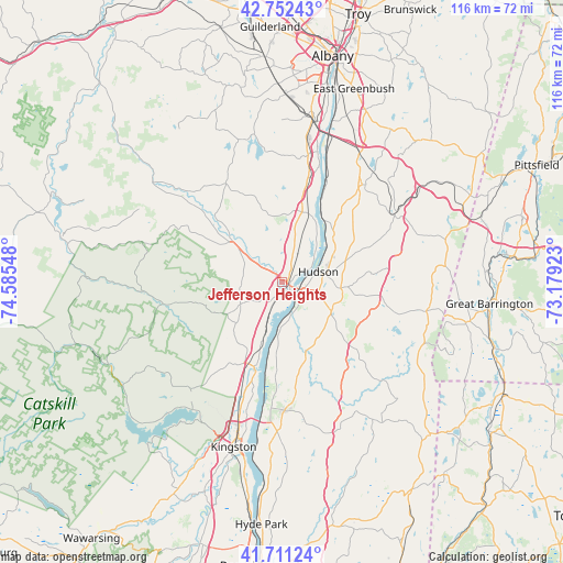
Jefferson Heights GPS coordinates[2]
42° 14' 2.328" North, 73° 52' 56.46" West
| Map corner | latitude | longitude |
|---|---|---|
| Upper-left | 42.75243°, | -74.58548° |
| Center: | 42.23398°, | -73.88235° |
| Lower-right: | 41.71124°, | -73.17923° |
| Map W x H: | 115.8×115.8 km | = 72×72mi |
| max Lat: | 71.29058° ⇑22.4% North |
| Jefferson Heights: | 42.23398° |
| min Lat: | ⇓77.6% South 19.06759° |
| min Long | Jefferson Heigh | max Long |
| -171.73463° | -73.88235° | -66.98998° |
| W 91.2%⇐ | ⇒8.8% E |
Elevation
Elevation of Jefferson Heights is 56 m = 184 ft, and this is 238.8 m = 783 ft below average elevation for this country.
| Max E: |
3189 m = 10463 ft | 77.9% |
| Avg. | 294.8 m = 967 ft | |
| Jefferson Heights | 56 m = 184 ft | |
Min E: |
-60 m = -197 ft | 22.1% |
See also: United States elevation on elevation.city.
Geographical zone
Jefferson Heights is located in North temperate zone (between Tropic of Cancer and the Arctic Circle). Distance of this Northern Tropic circle is 2090.1 km =1298.7 mi to South.| Distance of | km | miles | from Jefferson Heights |
|---|---|---|---|
| North Pole | 5311.1 | 3300.2 | to North |
| Arctic Circle | 2705.2 | 1680.9 | to North |
| Tropic Cancer | 2090.1 | 1298.7 | to South |
| Equator | 4696 | 2918 | to South |


Nearby cities:
15 places around Jefferson Heights: (largest is in red/bold)
• Athens
6.7 km =4.2 mi,  63°
63°
• Cairo
12 km =7.5 mi,  307°
307°
• Catskill
2.4 km =1.5 mi,  141°
141°
• Claverack-Red Mills
12.8 km =8 mi,  93°
93°
• Coxsackie
14.6 km =9.1 mi,  26°
26°
• Germantown
11.1 km =6.9 mi,  184°
184°
• Hudson
7.8 km =4.8 mi,  74°
74°
• Lorenz Park
9.9 km =6.2 mi, 70°
• Oakdale
8.6 km =5.3 mi,  77°
77°
• Palenville
13.1 km =8.1 mi,  239°
239°
• Philmont
18.9 km =11.7 mi, 85°
• Saugerties
18.3 km =11.4 mi,  198°
198°
• Saugerties South
20 km =12.4 mi, 196°
• Stottville
13.2 km =8.2 mi, 63°
• Tivoli
19.6 km =12.2 mi,  186°
186°
Sources, notices
• [Note1] Compared only with cities in United States existing in our database
• [Src1] Map data: © OpenStreetMap contributors (CC-BY-SA)
• [Src2] Other city data from geonames.org with taken over terms of usage.
• [Src3] Geographical zone / Annual Mean Temperature by Robert A. Rohde @ Wikipedia
