Syracuse geodata
Syracuse (New York) is a seat of a second-order administrative division; located in United States in America/New_York (GMT-4) time zone. With population of 144,142 people, there are 208 cities with bigger population in this country. Compared to other cities in United States, 83.6% of cities are located further ↓South; 83.6% of cities are located further ←West and 64.8% of cities have higher elevation than Syracuse. Note1


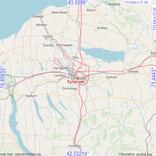
Syracuse GPS coordinates[2]
43° 2' 53.232" North, 76° 8' 50.712" West
| Map corner | latitude | longitude |
|---|---|---|
| Upper-left | 43.5598°, | -76.85055° |
| Center: | 43.04812°, | -76.14742° |
| Lower-right: | 42.53214°, | -75.4443° |
| Map W x H: | 114.3×114.3 km | = 71×71mi |
| max Lat: | 71.29058° ⇑16.4% North |
| Syracuse: | 43.04812° |
| min Lat: | ⇓83.6% South 19.06759° |
| min Long | Syracuse | max Long |
| -171.73463° | -76.14742° | -66.98998° |
| W 83.6%⇐ | ⇒16.4% E |
Elevation
Elevation of Syracuse is 129 m = 423 ft, and this is 165.8 m = 544 ft below average elevation for this country.
| Max E: |
3189 m = 10463 ft | 64.8% |
| Avg. | 294.8 m = 967 ft | |
| Syracuse | 129 m = 423 ft | |
Min E: |
-60 m = -197 ft | 35.2% |
See also: Syracuse elevation on elevation.city.
Geographical zone
Syracuse is located in North temperate zone (between Tropic of Cancer and the Arctic Circle). Distance of this Northern Tropic circle is 2180.6 km =1355 mi to South.| Distance of | km | miles | from Syracuse |
|---|---|---|---|
| North Pole | 5220.6 | 3243.9 | to North |
| Arctic Circle | 2614.7 | 1624.7 | to North |
| Tropic Cancer | 2180.6 | 1355 | to South |
| Equator | 4786.5 | 2974.2 | to South |


Nearby cities:
15 places around Syracuse: (largest is in red/bold)
• Camillus
12.8 km =8 mi,  265°
265°
• East Syracuse
5.9 km =3.7 mi,  71°
71°
• Fairmount
7.4 km =4.6 mi, 269°
• Fayetteville
11.8 km =7.3 mi,  99°
99°
• Galeville
5.1 km =3.2 mi,  336°
336°
• Lakeland
8.9 km =5.5 mi,  301°
301°
• Liverpool
8.6 km =5.3 mi,  318°
318°
• Lyncourt
4.1 km =2.5 mi,  25°
25°
• Mattydale
5.5 km =3.4 mi,  1°
1°
• Minoa
12.3 km =7.6 mi,  75°
75°
• Nedrow
8.1 km =5 mi,  176°
176°
• North Syracuse
9.7 km =6 mi,  8°
8°
• Seneca Knolls
13.8 km =8.6 mi,  305°
305°
• Solvay
5 km =3.1 mi,  282°
282°
• Westvale
5.9 km =3.7 mi, 269°
Sources, notices
• [Note1] Compared only with cities in United States existing in our database
• [Src1] Map data: © OpenStreetMap contributors (CC-BY-SA)
• [Src2] Other city data from geonames.org with taken over terms of usage.
• [Src3] Geographical zone / Annual Mean Temperature by Robert A. Rohde @ Wikipedia
