Unionville geodata
Unionville (New York) is a populated place; located in United States in America/New_York (GMT-4) time zone. With population of 593 people, there are 19785 cities with bigger population in this country. Compared to other cities in United States, 68.8% of cities are located further ↓South; 88.4% of cities are located further ←West and 58.6% of cities have higher elevation than Unionville. Note1


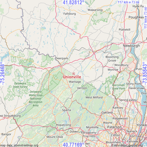
Unionville GPS coordinates[2]
41° 18' 7.344" North, 74° 33' 41.58" West
| Map corner | latitude | longitude |
|---|---|---|
| Upper-left | 41.82812°, | -75.26468° |
| Center: | 41.30204°, | -74.56155° |
| Lower-right: | 40.77169°, | -73.85843° |
| Map W x H: | 117.5×117.5 km | = 73×73mi |
| max Lat: | 71.29058° ⇑31.2% North |
| Unionville: | 41.30204° |
| min Lat: | ⇓68.8% South 19.06759° |
| min Long | Unionville | max Long |
| -171.73463° | -74.56155° | -66.98998° |
| W 88.4%⇐ | ⇒11.6% E |
Elevation
Elevation of Unionville is 162 m = 531 ft, and this is 132.8 m = 436 ft below average elevation for this country.
| Max E: |
3189 m = 10463 ft | 58.6% |
| Avg. | 294.8 m = 967 ft | |
| Unionville | 162 m = 531 ft | |
Min E: |
-60 m = -197 ft | 41.4% |
See also: United States elevation on elevation.city.
Geographical zone
Unionville is located in North temperate zone (between Tropic of Cancer and the Arctic Circle). Distance of this Northern Tropic circle is 1986.4 km =1234.3 mi to South.| Distance of | km | miles | from Unionville |
|---|---|---|---|
| North Pole | 5414.7 | 3364.5 | to North |
| Arctic Circle | 2808.8 | 1745.3 | to North |
| Tropic Cancer | 1986.4 | 1234.3 | to South |
| Equator | 4592.4 | 2853.6 | to South |


Nearby cities:
15 places around Unionville: (largest is in red/bold)
• Eden
5.8 km =3.6 mi,  104°
104°
• Florida
17.4 km =10.8 mi,  79°
79°
• Franklin
20.1 km =12.5 mi,  184°
184°
• Hamburg
16.6 km =10.3 mi, 184°
• Highland Lake
16.5 km =10.3 mi,  147°
147°
• Matamoras
13.7 km =8.5 mi,  302°
302°
• Mechanicstown
21.3 km =13.2 mi,  42°
42°
• Middletown
19.7 km =12.2 mi, 35°
• Milford
20.2 km =12.6 mi,  276°
276°
• Otisville
19.2 km =11.9 mi,  5°
5°
• Port Jervis
13.6 km =8.5 mi,  306°
306°
• Sussex
11 km =6.8 mi,  200°
200°
• Vernon Center
13.5 km =8.4 mi,  159°
159°
• Vernon Valley
9.6 km =6 mi,  139°
139°
• Warwick
17.6 km =10.9 mi,  106°
106°
Sources, notices
• [Note1] Compared only with cities in United States existing in our database
• [Src1] Map data: © OpenStreetMap contributors (CC-BY-SA)
• [Src2] Other city data from geonames.org with taken over terms of usage.
• [Src3] Geographical zone / Annual Mean Temperature by Robert A. Rohde @ Wikipedia
